
Nundah QLD Suburb Profile 2026: Land Values, Rent, Schools and Lifestyle

By Tim AllenBuyer’s Agent and Director, IPS Buyer’s Agents
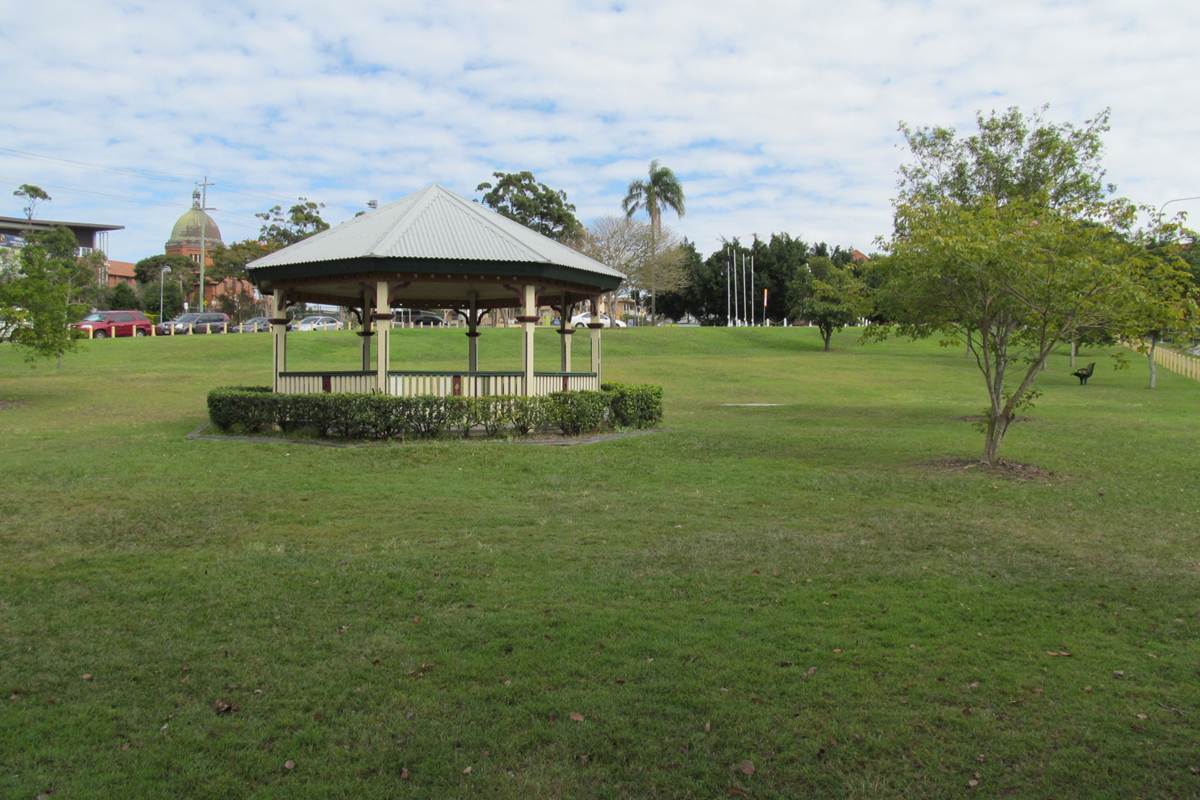
The rotunda in Boyd Park, 2013. Photo: Orderinchaos, CC BY-SA 4.0, via Wikimedia Commons.
Nundah (postcode 4012) is an inner northern Brisbane suburb about 9.5 km from the CBD by road, home to 13,098 people at the 2021 Census, with its village shops on Sandgate Road and two train stations, Nundah and Toombul. German missionaries settled here in 1838 and the area was called German Station until the railway came in 1882 and its station was renamed Nundah, from a Turrbal word for a chain of water holes. At the Queensland Valuer-General’s 2025 valuation the median value of residential land was $730,000, up 4.3% in two years, and homes were renting for $650 a week in September 2026.
Checked 20 November 2026. Every figure names its source, and the full list is under References at the end. Prices come from the Queensland Valuer-General’s land valuations, which the Queensland Government publishes for anyone to use.
Nundah at a glance
| Nundah, QLD 4012 | Figure | Source |
|---|---|---|
| Council | Brisbane City Council | Queensland Government |
| Distance to Brisbane CBD | About 9.5 km by road; 14 to 20 min drive off-peak, 16 to 35 min leaving at 7.30am | Google Maps, Nov 2026 |
| Population | 13,098 people, median age 35 | ABS Census 2021 |
| Median value of residential land | $730,000 at 1 October 2024, up 4.3% in two years (1,629 properties) | Queensland Valuer-General, 2025 valuation |
| Against Brisbane | About level with the city median of $720,000 (up 16.1%) | Queensland Valuer-General, 2025 valuation |
| Median rent, all homes | $650 a week (2-bed unit $650, 3-bed house $750, 3-bed townhouse $795) | RTA, Sep quarter 2026 |
| Rent since 2017 | All homes up from $375 to $650 a week (+73%) | RTA, September quarters |
| Homes rented | 55% (Queensland 33%) | ABS Census 2021 |
| Homes | 60% units and apartments, 24% separate houses, 16% townhouses and semis | ABS Census 2021 |
| State school catchments | Mostly Nundah State School; mostly Aviation High | Queensland Government, Jul 2026 |
| Public transport | Nundah and Toombul stations: about 28 min to the CBD by train | Google Maps, Nov 2026 |
| Nearest hub | Toombul, in the suburb (a major regional activity centre); Chermside 10 min | SEQ Regional Plan 2009–2031 |
| Biggest build | Former Toombul shopping centre: a 9.9 ha masterplan for shops first, then apartments and parkland | Irvine Group masterplan, 2026 |
| Reported offences | 1,075 in 12 months: about 82 per 1,000 residents (Brisbane: 90) | QPS Online Crime Map, Nov 2026 |
| Next land valuation | Brisbane is not in the 2027 program | Queensland Valuer-General |
Is Nundah a good place to live?
Nundah suits people who want inner-north living without inner-city prices: a village shopping strip, two train stations, the airport 8 to 10 minutes away and a 14 to 20 minute drive to the CBD outside peak hour, at a land value about level with Brisbane’s median. The trade-offs are flooding on the low ground along Kedron Brook and Schulz Canal, the noise of Sandgate Road and the railway, the long wait for the Toombul site to be rebuilt, and a market of mostly units: at the 2021 Census 60% of homes were units or apartments (Queensland: 13%), 55% were rented and 41% of households were one person.
It is really three places in one, and each comes with its own checks.
| Part of Nundah | What you get | What to check |
|---|---|---|
| The village and the stations | Apartments and townhouses around Sandgate Road, Nundah station and the village shops | The body corporate records, the proposed height limits for the sites around you, and train and road noise |
| The ridge and the older streets | Workers’ cottages and Queenslanders on the ridge and the streets off Buckland Road | The character overlay, the building report and the age of the stumps and wiring |
| Toombul and the creek | Units and houses on the low ground near Kedron Brook, Schulz Canal and the old shopping centre site | The flood map, the Toombul masterplan and what may be built next door |
What is the median house price in Nundah?
We use only free, open government data in this profile, and that has no current median sale price for Nundah. The official open measure is the Queensland Valuer-General’s median value of residential land: $730,000 at 1 October 2024, up 4.3% from $700,000 two years earlier, across 1,629 properties. That is about the same as Brisbane’s median of $720,000, which rose 16.1%.
Median value of residential land (Queensland Valuer-General, 2025 valuation):
| Area | Median at 1 Oct 2022 | Median at 1 Oct 2024 | Change | Properties |
|---|---|---|---|---|
| Nundah | $700,000 | $730,000 | +4.3% | 1,629 |
| Northgate | $630,000 | $660,000 | +4.8% | 1,245 |
| Virginia | $540,000 | $640,000 | +18.5% | 910 |
| Wavell Heights | $660,000 | $790,000 | +19.7% | 3,718 |
| Kalinga | $990,000 | $1,100,000 | +11.1% | 624 |
| Hendra | $970,000 | $1,150,000 | +18.6% | 1,640 |
| Clayfield | $1,000,000 | $1,150,000 | +15.0% | 2,074 |
| All of Brisbane | – | $720,000 | +16.1% | – |
A land valuation is the Valuer-General’s estimate of what the land alone was worth on the valuation date, without the house. It is not a sale price, and these figures are now two years old: Brisbane was last valued at 1 October 2024. It is not in the 2027 program, so these are the newest official figures; councils use them to set rates and the state uses them for land tax. Nundah’s land value rose much less than Wavell Heights’ or Clayfield’s over the two years, and with most homes in units, which share their land, the land figure says little about what a unit costs. For what homes have actually sold for, compare recent sales on the property portals, or ask us.
The median rent on new leases for all homes in Nundah was $650 a week in the September quarter 2026, up from $625 a year earlier and $375 in September 2017, according to the Residential Tenancies Authority’s bond data: a 73% rise in nine years.
| September quarter | All homes, Nundah (median weekly rent) |
|---|---|
| 2017 | $375 |
| 2019 | $375 |
| 2021 | $400 |
| 2022 | $450 |
| 2023 | $540 |
| 2024 | $585 |
| 2025 | $625 |
| 2026 | $650 |
By type in the September quarter 2026: one-bedroom units $500 a week, two-bedroom units $650, three-bedroom units $770, three-bedroom houses $750 and three-bedroom townhouses $795 (RTA).
Who rents. At the 2021 Census 55% of Nundah’s homes were rented, against 33% across Queensland; 28% were being paid off and 15% were owned outright (Queensland: 34% and 29%).
Most of Nundah is in the Nundah State School catchment, going by the Queensland Government’s July 2026 maps, with about a third in Northgate State School’s and a sliver in Virginia State School’s. For high school, most of it is in Aviation High’s catchment and the rest in Wavell State High School’s, with a sliver in Earnshaw State College’s.
| State school | Share of Nundah in its catchment | Enrolment management plan |
|---|---|---|
| Nundah State School | 63% | Yes |
| Northgate State School | 33% | Yes |
| Virginia State School | 4% | Yes |
| Aviation High | 81% | Yes |
| Wavell State High School | 18% | Yes |
The shares are of the locality’s mapped area, not homes, so put the exact address into the Queensland Government’s EdMap before you rely on a catchment. All five schools enforce their catchments under enrolment management plans, so they take children from outside only when they have room; you prove the address with a current lease, a rates notice or an unconditional contract, plus a utility bill. Nundah State School opened in 1865 as German Station State School and took its present name in 1895.
Nundah is about 9.5 km north-east of the Brisbane CBD by road. Driving to King George Square takes about 14 to 20 minutes outside peak hour and 16 to 35 minutes leaving at 7.30am on a weekday, through the Airport Link tunnel. The train is the easy way in: on a weekday morning a Shorncliffe line train from Nundah station took about 28 minutes door to door.
| From Nundah to | How | Typical time |
|---|---|---|
| Brisbane CBD (King George Square) | Car, leaving 7.30am weekday (9.7 km) | 16 to 35 min |
| Brisbane CBD | Car, off-peak | 14 to 20 min |
| Brisbane CBD | Train from Nundah station, leaving 7.30am | 28 min door to door |
| Brisbane Airport | Car, off-peak | 8 to 10 min |
| The Prince Charles Hospital, Chermside | Car, off-peak | 9 min |
| Westfield Chermside | Car, off-peak | 10 min |
| Sunshine Coast (Mooloolaba Beach) | Car, off-peak | 1 hr 5 min to 1 hr 15 min |
| Gold Coast (Surfers Paradise) | Car, off-peak | 1 hr to 1 hr 10 min |
On Census day 2021, 50% of Nundah’s workers drove or rode in a car to work, 15% took public transport, mostly the train (Queensland: 4%), and 21% worked from home (Queensland: 14%).
Nundah has a hub of its own at Toombul. The South East Queensland Regional Plan 2009–2031 named Toombul one of Brisbane’s major regional activity centres, with Mitchelton, Wynnum Central and Toowong, and Chermside, 10 minutes away, one of its four principal ones. The plan also named the Australia TradeCoast, which takes in Brisbane Airport, 8 to 10 minutes away, one of Brisbane’s enterprise areas for jobs.
Brisbane grows mostly by infill, and the council wants some of it in Nundah’s centre. The 2017 ShapingSEQ background paper on growth set Brisbane a benchmark of 188,200 more homes between 2016 and 2041, 176,800 of them in existing urban areas, and the council has proposed taller buildings in Nundah’s centre (below).
The biggest change coming to Nundah is the rebuild of the former Toombul shopping centre site: 9.9 hectares at 1015 Sandgate Road, empty since the centre closed after the 2022 floods and was demolished.
- Who: Brisbane developer Irvine Group, which agreed to buy the whole site from Mirvac in November 2025.
- The plan: a masterplan lodged with Brisbane City Council in 2026 seeks preliminary approval for a staged precinct: a retail core first, with fresh food, specialty shops and everyday services, then mid-rise apartments and a corridor of parkland along Kedron Brook that also carries and stores floodwater.
- Timing: construction of the first, retail stage was being targeted for April 2027, subject to approval (Nundah News, May 2026). No tenants have been confirmed.
- A taller centre: Brisbane City Council’s proposed amendment for Nundah’s centre would lift the height limit in the Major Centre zone east of Sandgate Road from 12 to 15 storeys and allow up to 10 storeys in parts of the mixed-use zone west of the railway. It does not cover the Toombul site, and it was with the Queensland Government for review in November 2026.
What it means if you buy in Nundah: shops are likely to come back to Toombul within a few years, with more apartments in and around the centre. If you are buying near Sandgate Road or the old centre, check what the new rules allow next door, and expect years of building nearby.
Brisbane Airport, Chermside and the CBD are all within 20 minutes outside peak hour, and 21% of Nundah’s workers worked from home on Census day 2021 (Queensland: 14%). Professionals were the biggest group of its workers.
- Jobs (2021 Census): professionals 30.0% (Queensland 21.4%), clerical and administrative workers 15.7%, managers 12.6%, community and personal service workers 11.3% and technicians and trades workers 10.1%.
- Top industries: hospitals 5.0%, cafes and restaurants 2.9%, computer system design 2.8% (Queensland 1.3%), state government administration 2.7% and aged care 2.6%.
- Work patterns: 73.3% of adults were in the labour force (Queensland 61.6%), 4.3% were unemployed (Queensland 5.4%) and the median household income was $1,769 a week.
Nundah’s reported crime rate is a little below Brisbane’s. It recorded 1,075 offences on the Queensland Police Service’s online crime map in the 12 months to 19 November 2026, about 82 for every 1,000 residents, against 90 per 1,000 across Brisbane. Drug offences were the largest group, at 276, just ahead of thefts, at 269.
| Offence type | Nundah, 12 months to 19 Nov 2026 |
|---|---|
| Drug offences | 276 |
| Other theft (not break-ins) | 269 |
| Unlawful entry (break-ins) | 94 |
| Traffic and related offences | 84 |
| Good order offences | 78 |
| Property damage | 69 |
| Other | 45 |
| Unlawful use of a motor vehicle | 44 |
| Assault | 37 |
| Fraud | 32 |
| Weapons Act offences | 24 |
| Handling stolen goods | 23 |
Police say the map’s figures are not official statistics and its locations show a general area; the rates use 2021 Census populations. There were 94 break-ins in the year, about 7 per 1,000 residents. Before you buy, look up your own street on the map.
Nundah is about the village on Sandgate Road, its cafes and restaurants, and the parks along Kedron Brook. Ratings are Google’s, checked 20 November 2026.
Parks
- Kalinga Park, next door on Kedron Brook: 4.6 stars from 1,164 reviews.
- Boyd Park, with its rotunda and a fenced dog park: 4.4 from 199 reviews.
- Nundah Memorial Park, Buckland Road: 4.3 from 46 reviews.
Food and coffee
- Rustichella Pasta Bar, Aspinall Street: 4.9 from 900 reviews.
- Piccolo Ristorante, Ryans Road: 4.9 from 1,095 reviews.
- Fuel & Co, Buckland Road: 4.5 from 1,076 reviews.
- Seoul Blues, Korean food on Buckland Road: 4.8 from 138 reviews.
- Mavvy Lane, Sandgate Road: 4.5 from 291 reviews.
For kids
- Tiddlywinks Dance & Play Cafe, an indoor playground on Melton Road: 4.8 from 609 reviews.
- The playground at Plaisted Place Park: 4.4 from 122 reviews.
For adults
- The Village Social, a bar on Sandgate Road: 4.6 from 301 reviews.
- Prince of Wales Hotel, Buckland Road: 4.0 from 1,440 reviews.
The local pub
The Royal Hotel, Nundah, 1259 Sandgate Road, in the middle of the village: rated 4.1 from 1,779 Google reviews, and our pick for a meal or a drink.
Check the flood map, the body corporate and the proposed height rules before you talk price in Nundah. These are the things that change a price here.
- Flood. The Toombul shopping centre closed after flooding in 2022, and low ground near Kedron Brook and Schulz Canal can flood. Get Brisbane City Council’s free FloodWise property report for the address.
- Units. Six in ten homes are units: read the body corporate records, the sinking fund, special levies and any building defects.
- What can be built next door. Read the council’s proposed height changes for Nundah’s centre and the Toombul masterplan for the sites around you.
- Noise. Homes near Sandgate Road, the railway and the Toombul site hear traffic, trains and, for some years, building work. Visit at peak hour.
- The school address. All five state schools that cover Nundah enforce their catchments. Check the exact address on EdMap.
IPS Buyer’s Agents buys across Brisbane for owner-occupiers and investors, including a family home at Upper Mount Gravatt and a first home in Yeronga. In Nundah, Zian and I check the flood map, the body corporate records and the building report before we talk price.
Comparing Nundah with Wavell Heights, Northgate or Clayfield? Book a free call and tell us your brief. See how we work as a Brisbane buyer’s agent, our Chermside and Sandgate profiles and our other Brisbane suburb reports.
Is Nundah in Brisbane?
Yes. Nundah is an inner northern suburb in Brisbane City Council, about 9.5 km from the CBD by road, between Clayfield and Northgate, with two train stations, Nundah and Toombul. It was called German Station until the 1880s, after a German mission set up there in 1838.
What is the land value in Nundah?
The Queensland Valuer-General put the median value of residential land in Nundah at $730,000 at 1 October 2024, up 4.3% in two years, across 1,629 properties: about the same as Brisbane’s median of $720,000. Brisbane is not in the 2027 valuation program.
How much is rent in Nundah?
About $650 a week for all homes on new leases in the September quarter 2026: $500 for a one-bedroom unit, $650 for a two-bedroom unit and $750 for a three-bedroom house (Residential Tenancies Authority). Rents for all homes are up 73% since 2017.
Which school catchment is Nundah in?
Most of Nundah is in the Nundah State School catchment for primary, with about a third in Northgate State School’s, and most of it is in Aviation High’s catchment for high school, with the rest in Wavell State High School’s. All of them enforce their catchments, so check the exact address on EdMap.
How far is Nundah from Brisbane?
About 9.5 km: 14 to 20 minutes by car to the CBD outside peak hour, and 16 to 35 minutes leaving at 7.30am. The train from Nundah station takes about 28 minutes door to door. Brisbane Airport is 8 to 10 minutes away.
Is Nundah safe?
Its reported crime rate is a little below Brisbane’s: 1,075 offences on the police crime map in the 12 months to 19 November 2026, about 82 per 1,000 residents against 90 across Brisbane. Drug offences were the largest group, at 276, and there were 94 break-ins.
What is happening to the old Toombul shopping centre?
The 9.9 hectare site at 1015 Sandgate Road, closed after the 2022 floods and since demolished, was sold by Mirvac to Irvine Group in late 2025. A masterplan lodged with Brisbane City Council in 2026 puts a new retail centre first, then apartments and parkland along Kedron Brook; construction was being targeted for April 2027, subject to approval.
Who lives in Nundah?
Young professionals and renters: at the 2021 Census the median age was 35, 55% of homes were rented (Queensland: 33%), 60% were units or apartments and 41% of households were one person. Three in four adults were in the labour force, well above Queensland’s 62%.
- Queensland Valuer-General: Land valuation update 2025, Brisbane (median value of residential land, valuation date 1 October 2024), from the past valuation overviews
- Queensland Valuer-General: land valuations in 2027
- Residential Tenancies Authority: median rents by suburb, September quarters 2017 to 2026
- Australian Bureau of Statistics: 2021 Census QuickStats, Nundah
- Queensland Government: state school catchments, July 2026
- Department of Education: school enrolment management plans
- Queensland Police Service: Online Crime Map, 20 November 2025 to 19 November 2026
- Queensland Government: South East Queensland Regional Plan 2009–2031, Part C (Brisbane)
- Queensland Government: ShapingSEQ 2017, Background paper 1: Grow, Table 9 (dwelling supply benchmarks to 2041)
- The Urban Developer: Masterplan revealed for Toombul shopping centre site resurrection, 7 October 2026
- Mirvac: Mirvac and Irvine Group exchange contracts for the sale of the Toombul shopping centre site, 12 November 2025
- Nundah News: Nundah looks ahead as Toombul’s next chapter takes shape, 26 May 2026
- Brisbane City Council: Tailored amendment package, Indooroopilly, Carindale and Nundah major centres
- Brisbane City Council: FloodWise property reports
- Wikipedia: Nundah, Queensland
- Google Maps: drive times and ratings, checked 20 November 2026