
Nanango QLD Suburb Profile 2026: Land Values, Rent, Schools and Lifestyle

By Tim AllenBuyer’s Agent and Director, IPS Buyer’s Agents
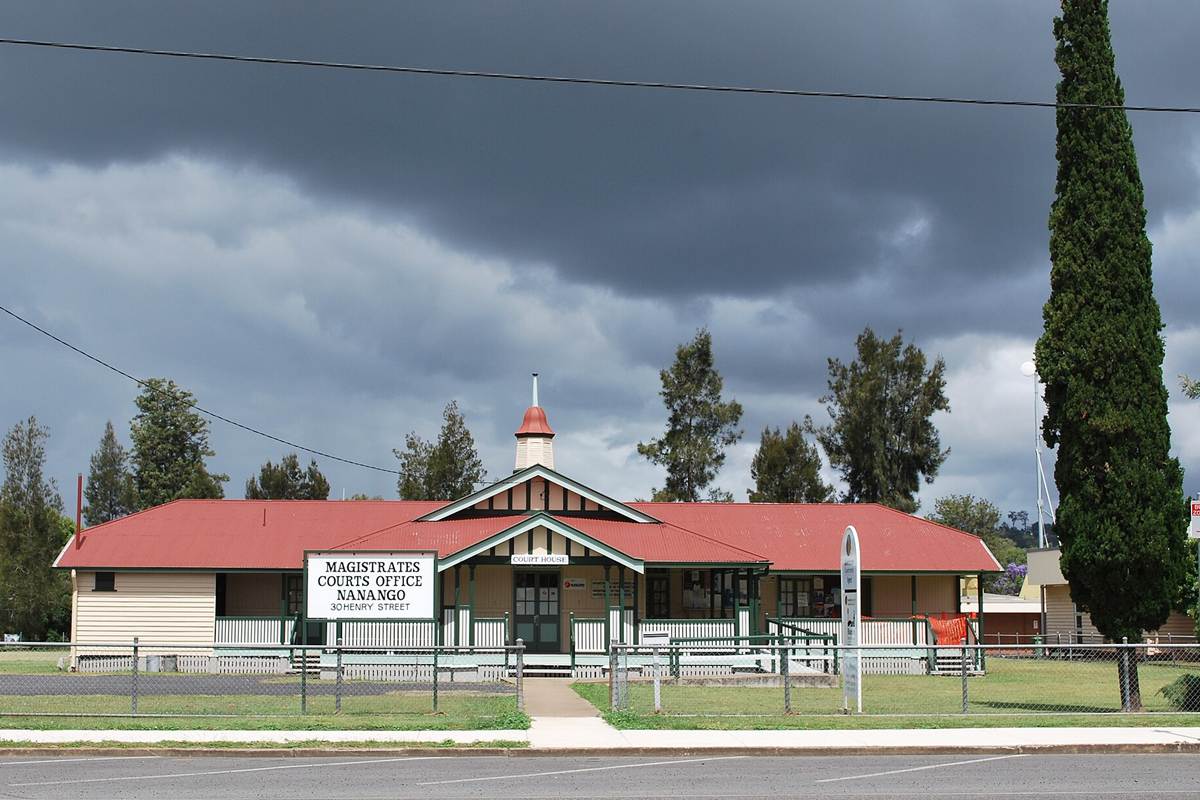
Nanango Court House on Henry Street, November 2010. Photo: Mattinbgn, CC BY-SA 3.0, via Wikimedia Commons.
Nanango (postcode 4615) is a country town in the South Burnett about 196 km north-west of Brisbane by road, home to 3,679 people at the 2021 Census. It grew from Goode’s Inn, opened in 1848 where the tracks from the Darling Downs, the Burnett and the Brisbane Valley met, and it claims to be one of Queensland’s oldest towns; electricity generation at Tarong and coal mining are among its industries today. At the Queensland Valuer-General’s 2025 valuation the median value of residential land was $88,000, double its 2021 level, and homes were renting for $375 a week in September 2026.
Checked 21 November 2026. Every figure names its source, and the full list is under References at the end. Prices come from the Queensland Valuer-General’s land valuations, which the Queensland Government publishes for anyone to use.
Nanango at a glance
| Nanango, QLD 4615 | Figure | Source |
|---|---|---|
| Council | South Burnett Regional Council | Queensland Government |
| Distance to Brisbane CBD | About 196 km by road; 2 hr 20 min to 2 hr 30 min drive off-peak, 2 hr 20 min to 3 hr leaving at 7.30am | Google Maps, Nov 2026 |
| Population | 3,679 people, median age 53 | ABS Census 2021 |
| Median value of residential land | $88,000 at 1 October 2024, up 100% in three years (1,079 properties) | Queensland Valuer-General, 2025 valuation |
| Against South Burnett | 4% above the regional median of $85,000 (up 57.4%) | Queensland Valuer-General, 2025 valuation |
| Median rent, all homes | $375 a week (3-bed house $440 in the June quarter) | RTA, Sep quarter 2026 |
| Rent since 2017 | All homes up from $250 to $375 a week (+50%) | RTA, September quarters |
| Homes rented | 32% (Queensland 33%) | ABS Census 2021 |
| Homes | 88% separate houses, 7% flats and units | ABS Census 2021 |
| State school catchments | Nanango State School; Nanango State High School | Queensland Government, Jul 2026 |
| Public transport | No passenger train; Google Maps found no public transport to the CBD on a weekday morning | Google Maps, Nov 2026 |
| Nearest hub | Kingaroy, the regional centre: Kingaroy Hospital 22 min; Nanango Hospital in town | Wide Bay Burnett Regional Plan 2023 |
| Biggest build nearby | D’Aguilar Highway, Nanango to Kingaroy: $42.61 million of safety works, finished April 2026 | Transport and Main Roads |
| Reported offences | 353 in 12 months: about 96 per 1,000 residents (South Burnett: 109) | QPS Online Crime Map, Nov 2026 |
| Next land valuation | South Burnett is not in the 2027 program; last valued at 1 October 2024 | Queensland Valuer-General |
Is Nanango a good place to live?
Is Nanango a good place to live? For buyers who want an old country town on the D’Aguilar Highway, a little closer to Brisbane than Kingaroy, it is worth a close look: it has its own hospital, state primary and high schools, an aquatic centre and the big monthly country markets, and its reported crime rate is below the South Burnett’s. The trade-offs are that Kingaroy’s hospital and main shops are 20 to 22 minutes away, there is no public transport to Brisbane, and the population is older, with fewer people working: at the 2021 Census the median age was 53 and 41% of homes were owned outright.
It is really three places in one, and each comes with its own checks.
| Part of Nanango | What you get | What to check |
|---|---|---|
| The old town around Drayton Street | Queenslanders and older timber houses near the shops, the court house and the schools | The building report, termites, asbestos and the highway traffic on Drayton Street |
| Along Sandy Creek | Houses near the creek that winds through the town | The flood map, the floor level and drainage |
| The outskirts | Newer houses and small acreage on the edges, toward the farms and Tarong | The water supply, septic systems, and farm and industrial neighbours |
What is the median house price in Nanango?
We use only free, open government data in this profile, and that has no current median sale price for Nanango. The official open measure is the Queensland Valuer-General’s median value of residential land: $88,000 at 1 October 2024, double the $44,000 of three years earlier, across 1,079 properties. That is about 4% above the South Burnett median of $85,000, which rose 57.4%.
Median value of residential land (Queensland Valuer-General, 2025 valuation):
| Area | Median at 1 Oct 2021 | Median at 1 Oct 2024 | Change | Properties |
|---|---|---|---|---|
| Nanango | $44,000 | $88,000 | +100.0% | 1,079 |
| Kingaroy | $67,000 | $90,000 | +34.3% | 3,436 |
| Blackbutt | $68,000 | $129,000 | +89.7% | 367 |
| Benarkin | $46,000 | $87,000 | +89.1% | 54 |
| Wondai | $37,000 | $78,000 | +110.8% | 702 |
| Murgon | $33,000 | $50,000 | +51.5% | 882 |
| All of South Burnett Regional | – | $85,000 | +57.4% | – |
A land valuation is the Valuer-General’s estimate of what the land alone was worth on the valuation date, without the house. It is not a sale price, and these figures are now two years old: South Burnett was last valued at 1 October 2024 and is not in the 2027 program, so they are still the current values; councils use them to set rates and the state uses them for land tax. Nanango’s land is now valued close to Kingaroy’s after doubling in three years, below Blackbutt’s and above Wondai’s and Murgon’s. The Valuer-General put the region’s rise down to demand for a rural lifestyle, prices well below South East Queensland’s and people moving up from the south-east, and noted bigger rises in rural residential land close to Kingaroy, Nanango and Blackbutt. For what homes have actually sold for, compare recent sales on the property portals, or ask us.
The median rent on new leases for all homes in Nanango was $375 a week in the September quarter 2026, up from $365 a year earlier and $250 in September 2017, according to the Residential Tenancies Authority’s bond data: up 50% in nine years.
| September quarter | All homes, Nanango (median weekly rent) |
|---|---|
| 2017 | $250 |
| 2019 | $230 |
| 2021 | $260 |
| 2022 | $300 |
| 2023 | $360 |
| 2024 | $350 |
| 2025 | $365 |
| 2026 | $375 |
A town of Nanango’s size has few new bonds each quarter, so the median jumps about: it was $420 in the March quarter 2026 and $440 in the June quarter, when three-bedroom houses also let for $440 a week (RTA).
Who rents. At the 2021 Census 32% of Nanango’s homes were rented, against 33% across Queensland; 23% were being paid off and 41% were owned outright (Queensland: 34% and 29%).
Going by the Queensland Government’s July 2026 maps, all of Nanango is in Nanango State School’s catchment for primary school and Nanango State High School’s for Years 7 to 12.
| State school | Share of Nanango in its catchment | Enrolment management plan |
|---|---|---|
| Nanango State School | 100% | No |
| Nanango State High School | 100% | Yes |
The shares are of the locality’s mapped area, not homes, so put the exact address into the Queensland Government’s EdMap before you rely on a catchment. Nanango State High School enforces its catchment under an enrolment management plan, so it takes students from outside only when it has room; you prove the address with a current lease, a rates notice or an unconditional contract, plus a utility bill. The primary school does not. St Patrick’s Primary School, a Catholic Prep to Year 6 school on Alfred Street, is the town’s private school.
Nanango is about 196 km north-west of the Brisbane CBD by road, on the D’Aguilar Highway. Driving to King George Square takes about 2 hr 20 min to 2 hr 30 min outside peak hour and 2 hr 20 min to 3 hr leaving at 7.30am on a weekday. There is no passenger train, and Google Maps found no public transport to the CBD on a weekday morning, so plan on driving.
| From Nanango to | How | Typical time |
|---|---|---|
| Brisbane CBD (King George Square) | Car, leaving 7.30am weekday | 2 hr 20 min to 3 hr |
| Brisbane CBD | Car, off-peak (196 km) | 2 hr 20 min to 2 hr 30 min |
| Brisbane CBD | Public transport | None found on a weekday morning |
| Nanango Hospital | Car, off-peak | 3 min |
| Kingaroy Hospital | Car, off-peak | 22 min |
| Kingaroy Mall, Alford Street | Car, off-peak | 20 min |
| Bunya Mountains National Park (Dandabah) | Car, off-peak | 50 min |
| Toowoomba (Grand Central) | Car, off-peak (138 km) | 1 hr 40 min |
| Brisbane Airport | Car, off-peak | 2 hr 10 min |
| Gold Coast (Surfers Paradise) | Car, off-peak | 2 hr 50 min to 3 hr 20 min |
| Sunshine Coast (Mooloolaba Beach) | Car, off-peak | 2 hr 10 min |
On Census day 2021, 70% of Nanango’s workers drove or rode in a car to work, 7% walked, 1% took a bus and 6% worked from home (Queensland: 14%).
Kingaroy, 20 to 22 minutes north-west along the D’Aguilar Highway, is Nanango’s hub for the main hospital, the bigger shops and council services. Nanango has its own public hospital on Brisbane Street, a library, the South Burnett Aquatic Centre and a main street of shops. The Queensland Government’s Wide Bay Burnett Regional Plan 2023 lists Kingaroy as one of the region’s regional centres and calls for new housing in the South Burnett to be consolidated around Kingaroy and within existing centres.
Nanango is closer to Brisbane and Toowoomba than Kingaroy is: the Brisbane CBD is about 196 km away and Toowoomba 1 hr 40 min, against 220 km and 1 hr 50 min from Kingaroy. The plan projects the South Burnett’s population to grow by 3,366, to 36,691, by 2046.
The biggest recent project for Nanango is the upgrade of 24 km of the D’Aguilar Highway between Nanango and Kingaroy by Transport and Main Roads: $42.61 million of safety and traffic works, with the final package finished in April 2026.
- What it added: wide centre line treatments to separate oncoming traffic, dedicated right-turn lanes at several intersections, audio tactile line marking, pavement reconstruction, and a realignment between Bushnells Road and Parsons Road.
- Town water: the council’s draft Nanango Community Plan 2025 lists planning for a new bulk water supply for Nanango from the Tarong pipeline (Boondooma Dam), and, in the long term, changing the supply from semi-potable bore water to potable dam water.
- Parks and pool: Pioneer Park’s playground is due for replacement and the aquatic centre’s hydrotherapy pool for a new heat pump (same plan).
- Sewer and water mains: a sewer main extension along Palace Lane and water main renewals on several streets (same plan).
What it means if you buy in Nanango: a quicker, safer drive to Kingaroy’s hospital and shops, which Nanango relies on. Before you buy, ask how the property gets its water: the council’s plan describes Nanango’s supply as semi-potable bore water, to be replaced with dam water in the long term.
Nanango’s own jobs are in its schools, shops, hospital and services, with farming, electricity generation at Tarong and coal mining in the district; many workers drive to Kingaroy.
- Jobs (2021 Census): labourers 19.4% (Queensland 10.1%), professionals 15.1% (Queensland 21.4%), technicians and trades workers 13.9%, community and personal service workers 13.3% and sales workers 10.9%.
- Top industries: secondary schools 4.5%, primary schools 4.4%, supermarkets 4.2%, meat processing 3.9% and hospitals 3.9%.
- Work patterns: 36.3% of adults were in the labour force (Queensland 61.6%), 9.3% were unemployed (Queensland 5.4%) and the median household income was $865 a week.
Nanango’s reported crime rate is below the South Burnett’s. It recorded 353 offences on the Queensland Police Service’s online crime map in the 12 months to 20 November 2026, about 96 for every 1,000 residents, against 109 per 1,000 across the region. Drug offences were the largest group, at 57, followed by traffic offences (54) and property damage (52).
| Offence type | Nanango, 12 months to 20 Nov 2026 |
|---|---|
| Drug offences | 57 |
| Traffic and related offences | 54 |
| Property damage | 52 |
| Other theft (not break-ins) | 51 |
| Good order offences | 45 |
| Assault | 30 |
| Unlawful entry (break-ins) | 24 |
| Other | 23 |
| Unlawful use of a motor vehicle | 9 |
| Other offences against the person | 8 |
Police say the map’s figures are not official statistics and its locations show a general area; the rates use 2021 Census populations. There were 24 break-ins in the year, about 7 per 1,000 residents. Before you buy, look up your own street on the map.
Nanango is about its heritage buildings, the country markets on the first Saturday of the month, its parks and the Bunya Mountains 50 minutes away. Ratings are Google’s, checked 21 November 2026.
Parks
- Butter Factory Park: 4.5 stars from 82 reviews.
- Nanango Showground: 4.5 from 138 reviews.
- Pioneer Park Amphitheatre: 4.1 from 30 reviews.
Food and coffee
- Burning Oil Cafe: 4.7 from 168 reviews.
- Thai@81: 4.6 from 131 reviews.
- Crustys Pizzaellie: 4.5 from 158 reviews.
- Twisted Whisk Bakehouse: 4.3 from 572 reviews.
For kids
- South Burnett Aquatic Centre: 4.5 from 32 reviews.
- Nanango Country Market, first Saturday of the month: 4.5 from 446 reviews.
For adults
- Barkers Creek Restaurant and Bar: 4.9 from 38 reviews.
- Nanango Visitor Information Centre and South Burnett Energy Centre: 4.7 from 39 reviews.
- Maidenwell Hotel, Maidenwell, on the way to the Bunya Mountains: 4.5 from 529 reviews.
The local pub
The Commercial Hotel, 69 Drayton Street, in the main street: rated 4.7 from 100 Google reviews, and our pick for a meal or a drink in town.
Check the water supply, the flood map and the building report before you talk price in Nanango. These are the things that change a price here.
- Water. The council’s plan describes the town supply as semi-potable bore water. Ask what the property is connected to, whether it has rainwater tanks for drinking, and on the outskirts whether it has town water or sewer at all.
- Flood. Sandy Creek winds through the town. Check South Burnett Regional Council’s flood mapping for the exact address and the floor level.
- The street. Reported crime varies from street to street. Look up the street on the police crime map, and visit at night as well as by day.
- Rural and industrial neighbours. On the outskirts, farms and the power station and mine district to the south-west can mean noise, dust and trucks. Check the zoning next door and drive past at different times.
- Condition. Many homes are old timber Queenslanders. Book a building and pest inspection, ask about asbestos, and check that extensions were approved.
IPS Buyer’s Agents works only for buyers, and we buy in Nanango, Kingaroy and the South Burnett for our clients. In Nanango, Zian and I check the water supply, the flood map and the building report before we talk price.
Comparing Nanango with Kingaroy, Wondai or Murgon? Book a free call and tell us your brief. See our Kingaroy profile, our Kingaroy infrastructure guide and our other South Burnett suburb reports.
Is Nanango a good place to live?
For buyers who want an old country town on the D’Aguilar Highway, a little closer to Brisbane than Kingaroy, it is worth a close look: it has its own hospital, state primary and high schools, an aquatic centre and the big monthly country markets, and its reported crime rate is below the South Burnett’s. The trade-offs are that Kingaroy’s hospital and main shops are 20 to 22 minutes away, there is no public transport to Brisbane, and the population is older, with fewer people working.
What is the land value in Nanango?
The Queensland Valuer-General put the median value of residential land in Nanango at $88,000 at 1 October 2024, double the $44,000 of three years earlier, across 1,079 properties: about 4% above the South Burnett median of $85,000, which rose 57.4%. South Burnett is not in the 2027 valuation program, so these are still the current values.
How much is rent in Nanango?
About $375 a week for all homes on new leases in the September quarter 2026, up 50% from $250 in September 2017 (Residential Tenancies Authority). A town of Nanango’s size has few new bonds each quarter, so the median jumps about: it was $440 in the June quarter 2026, when three-bedroom houses also let for $440.
Which school catchment is Nanango in?
All of Nanango is in the catchments of Nanango State School and Nanango State High School. The high school enforces its catchment under an enrolment management plan, so check the exact address on EdMap. St Patrick’s Primary School is the town’s Catholic primary school.
How far is Nanango from Brisbane?
About 196 km by road: 2 hr 20 min to 2 hr 30 min to the CBD by car outside peak hour and 2 hr 20 min to 3 hr leaving at 7.30am. There is no passenger train, and Google Maps found no public transport to the CBD on a weekday morning. Kingaroy Hospital is 22 minutes away, Toowoomba 1 hr 40 min and Brisbane Airport 2 hr 10 min.
Is Nanango safe?
Its reported crime rate is below the South Burnett’s: 353 offences on the police crime map in the 12 months to 20 November 2026, about 96 per 1,000 residents against 109 across the region. Drug offences (57), traffic offences (54) and property damage (52) were the largest groups, and there were 24 break-ins.
What is being built near Nanango?
The D’Aguilar Highway between Nanango and Kingaroy has just been upgraded: 24 km of wider centre lines, turning lanes, safety line marking, new pavement and a realignment, $42.61 million, with the last works finished in April 2026. The council’s plans also include a new bulk water supply for Nanango from the Tarong pipeline, now at planning.
Who lives in Nanango?
An older town: at the 2021 Census the median age was 53, 41% of homes were owned outright (Queensland 29%), 37% of households were people living alone and the median household income was $865 a week. Only 36% of adults were in the labour force, against 62% across Queensland.
- Queensland Valuer-General: Land valuation update 2025, South Burnett Regional (median value of residential land by locality, valuation date 1 October 2024), from the past valuation overviews
- Queensland Valuer-General: land valuations in 2027
- Residential Tenancies Authority: median rents by suburb, September quarters 2017 to 2026
- Australian Bureau of Statistics: 2021 Census QuickStats, Nanango
- Queensland Government: state school catchments, July 2026
- Department of Education: school enrolment management plans
- Queensland Police Service: Online Crime Map, 21 November 2025 to 20 November 2026
- Queensland Government: Wide Bay Burnett Regional Plan 2023
- Department of Transport and Main Roads: D’Aguilar Highway (Yarraman – Kingaroy), various locations, improve safety
- South Burnett Regional Council: draft Nanango Community Plan 2025
- Wikipedia: Nanango
- Google Maps: drive times and ratings, checked 21 November 2026