
Kingaroy QLD Suburb Profile 2026: Land Values, Rent, Schools and Lifestyle

By Tim AllenBuyer’s Agent and Director, IPS Buyer’s Agents
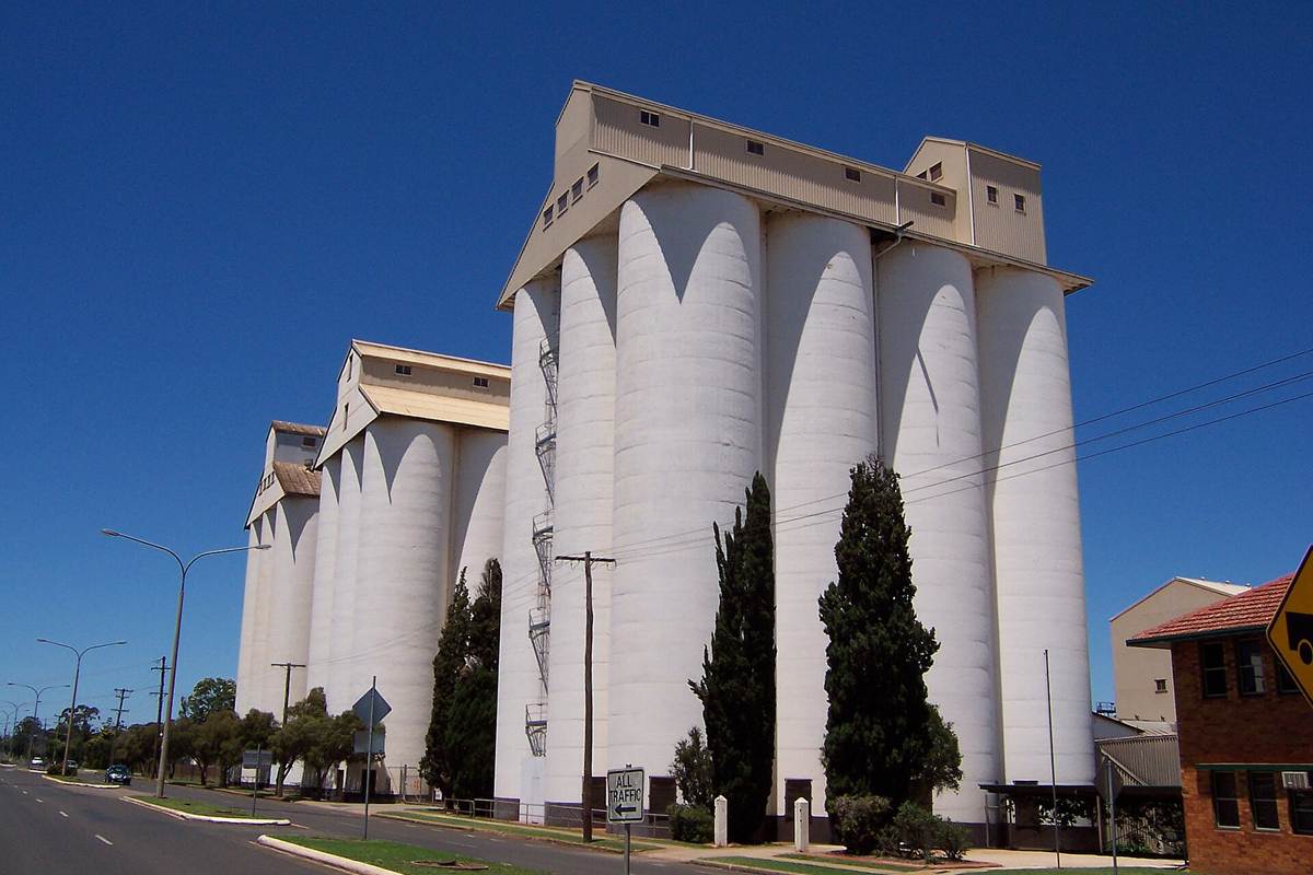
The peanut silos on Haly Street, Kingaroy’s heritage-listed landmark, October 2005. Photo: Rossrs at English Wikipedia, public domain, via Wikimedia Commons.
Kingaroy (postcode 4610) is the largest town in the South Burnett, about 220 km north-west of Brisbane by road, and home to 10,266 people at the 2021 Census. It is the seat of South Burnett Regional Council and is known as the peanut capital of Australia: its heritage-listed peanut silos tower over Haly Street, and the region’s peanut, navy bean, pork and wine industries grew up around it. Its name is usually said to come from the Wakka Wakka word for a red ant. At the Queensland Valuer-General’s 2025 valuation the median value of residential land was $90,000, up 34.3% in three years, and homes were renting for $510 a week in September 2026.
Checked 21 November 2026. Every figure names its source, and the full list is under References at the end. Prices come from the Queensland Valuer-General’s land valuations, which the Queensland Government publishes for anyone to use.
Kingaroy at a glance
| Kingaroy, QLD 4610 | Figure | Source |
|---|---|---|
| Council | South Burnett Regional Council | Queensland Government |
| Distance to Brisbane CBD | About 220 km by road; 2 hr 30 min to 2 hr 50 min drive off-peak, 2 hr 40 min to 3 hr 20 min leaving at 7.30am | Google Maps, Nov 2026 |
| Population | 10,266 people, median age 38 | ABS Census 2021 |
| Median value of residential land | $90,000 at 1 October 2024, up 34.3% in three years (3,436 properties) | Queensland Valuer-General, 2025 valuation |
| Against South Burnett | 6% above the regional median of $85,000 (up 57.4%) | Queensland Valuer-General, 2025 valuation |
| Median rent, all homes | $510 a week (3-bed house $540; 4-bed house $620; 2-bed unit $420) | RTA, Sep quarter 2026 |
| Rent since 2017 | All homes up from $255 to $510 a week (+100%) | RTA, September quarters |
| Homes rented | 37% (Queensland 33%) | ABS Census 2021 |
| Homes | 86% separate houses, 9% flats and units | ABS Census 2021 |
| State school catchments | Kingaroy, Crawford or Taabinga State School; Kingaroy State High School | Queensland Government, Jul 2026 |
| Public transport | No passenger train; Google Maps found no public transport to the CBD on a weekday morning | Google Maps, Nov 2026 |
| Nearest hub | Kingaroy itself, a regional centre in the state’s regional plan: Kingaroy Hospital 3 min | Wide Bay Burnett Regional Plan 2023 |
| Biggest build nearby | Trunk sewer and water main upgrades so new estates can connect | South Burnett Regional Council |
| Reported offences | 1,517 in 12 months: about 148 per 1,000 residents (South Burnett: 109) | QPS Online Crime Map, Nov 2026 |
| Next land valuation | South Burnett is not in the 2027 program; last valued at 1 October 2024 | Queensland Valuer-General |
Is Kingaroy a good place to live?
Is Kingaroy a good place to live? For buyers who want a full-service country town, yes: Kingaroy is the South Burnett’s largest town and the council’s seat, with Kingaroy Hospital, the region’s main shops and a state high school, and the Queensland Government’s regional plan wants new housing in the South Burnett concentrated here. The trade-offs are the distance (2 hr 30 min to 3 hr 20 min to the Brisbane CBD by car, with no public transport found on Google Maps), a reported crime rate above the region’s, and land that has risen less than in the smaller towns. At the 2021 Census 37% of homes were rented and the median age was 38, ten years younger than the region’s.
It is really three places in one, and each comes with its own checks.
| Part of Kingaroy | What you get | What to check |
|---|---|---|
| The town centre and older streets | Queenslanders and post-war houses within walking distance of Haly and Alford streets, the hospital and the schools | The building report, termites, asbestos in older homes and traffic on the highway streets |
| Newer estates on the edges | Brick houses from the 1990s on, on bigger blocks around Taabinga and Kingaroy Heights | The water and sewer connection, the estate covenants and which school catchment the street is in |
| The rural fringe | Acreage near the farms, the airport and the Stuart River on the western outskirts | The flood map, farm and aerodrome noise, tank water and septic systems |
What is the median house price in Kingaroy?
We use only free, open government data in this profile, and that has no current median sale price for Kingaroy. The official open measure is the Queensland Valuer-General’s median value of residential land: $90,000 at 1 October 2024, up 34.3% from $67,000 three years earlier, across 3,436 properties. That is about 6% above the South Burnett median of $85,000, which rose 57.4%.
Median value of residential land (Queensland Valuer-General, 2025 valuation):
| Area | Median at 1 Oct 2021 | Median at 1 Oct 2024 | Change | Properties |
|---|---|---|---|---|
| Kingaroy | $67,000 | $90,000 | +34.3% | 3,436 |
| Nanango | $44,000 | $88,000 | +100.0% | 1,079 |
| Wondai | $37,000 | $78,000 | +110.8% | 702 |
| Murgon | $33,000 | $50,000 | +51.5% | 882 |
| Blackbutt | $68,000 | $129,000 | +89.7% | 367 |
| Kumbia | $34,000 | $65,000 | +91.2% | 104 |
| Memerambi | $27,000 | $55,000 | +103.7% | 133 |
| All of South Burnett Regional | – | $85,000 | +57.4% | – |
A land valuation is the Valuer-General’s estimate of what the land alone was worth on the valuation date, without the house. It is not a sale price, and these figures are now two years old: South Burnett was last valued at 1 October 2024 and is not in the 2027 program, so they are still the current values; councils use them to set rates and the state uses them for land tax. Kingaroy’s land is valued above every other locality on the Valuer-General’s South Burnett list except Blackbutt, but it rose the least. The Valuer-General put the region’s rise down to demand for a rural lifestyle, prices well below South East Queensland’s and people moving up from the south-east. Rural residential land across South Burnett went from $89,000 to $155,000 (+74.2%). For what homes have actually sold for, compare recent sales on the property portals, or ask us.
The median rent on new leases for all homes in Kingaroy was $510 a week in the September quarter 2026, up from $500 a year earlier and $255 in September 2017, according to the Residential Tenancies Authority’s bond data: double in nine years.
| September quarter | All homes, Kingaroy (median weekly rent) |
|---|---|
| 2017 | $255 |
| 2019 | $275 |
| 2021 | $310 |
| 2022 | $360 |
| 2023 | $390 |
| 2024 | $420 |
| 2025 | $500 |
| 2026 | $510 |
By type, three-bedroom houses let for $540 a week in the September quarter 2026, four-bedroom houses for $620 and two-bedroom units for $420 (RTA).
Who rents. At the 2021 Census 37% of Kingaroy’s homes were rented, against 33% across Queensland; 28% were being paid off and 32% were owned outright (Queensland: 34% and 29%).
Going by the Queensland Government’s July 2026 maps, Kingaroy State School’s catchment covers about 56% of the town’s area, Crawford State School’s 24% and Taabinga State School’s 18%, with about 1% in Coolabunia State School’s. All of Kingaroy is in Kingaroy State High School’s catchment.
| State school | Share of Kingaroy in its catchment | Enrolment management plan |
|---|---|---|
| Kingaroy State School | 56% | No |
| Crawford State School | 24% | Yes |
| Taabinga State School | 18% | No |
| Coolabunia State School | 1% | Yes |
| Kingaroy State High School | 100% | No |
The shares are of the locality’s mapped area, not homes, so put the exact address into the Queensland Government’s EdMap before you rely on a catchment. Crawford and Coolabunia state schools enforce their catchments under enrolment management plans, so they take children from outside only when they have room; you prove the address with a current lease, a rates notice or an unconditional contract, plus a utility bill. The other three do not. Saint Mary’s Catholic College (Prep to Year 12) on Kent Street and St John’s Lutheran School (Prep to Year 9) on Ivy Street are the town’s private schools.
Kingaroy is about 220 km north-west of the Brisbane CBD by road, mostly on the D’Aguilar Highway. Driving to King George Square takes about 2 hr 30 min to 2 hr 50 min outside peak hour and 2 hr 40 min to 3 hr 20 min leaving at 7.30am on a weekday. There is no passenger train, and Google Maps found no public transport to the CBD on a weekday morning, so plan on driving.
| From Kingaroy to | How | Typical time |
|---|---|---|
| Brisbane CBD (King George Square) | Car, leaving 7.30am weekday | 2 hr 40 min to 3 hr 20 min |
| Brisbane CBD | Car, off-peak (220 km) | 2 hr 30 min to 2 hr 50 min |
| Brisbane CBD | Public transport | None found on a weekday morning |
| Kingaroy Hospital | Car, off-peak | 3 min |
| Kingaroy Mall, Alford Street | Car, off-peak | 2 min |
| Bunya Mountains National Park (Dandabah) | Car, off-peak | 55 min |
| Toowoomba (Grand Central) | Car, off-peak (152 km) | 1 hr 50 min |
| Brisbane Airport | Car, off-peak | 2 hr 30 min |
| Gold Coast (Surfers Paradise) | Car, off-peak | 3 hr 10 min to 3 hr 30 min |
| Sunshine Coast (Mooloolaba Beach) | Car, off-peak | 2 hr 30 min |
On Census day 2021, 77% of Kingaroy’s workers drove or rode in a car to work, 4% walked, 1% took a bus and 4% worked from home (Queensland: 14%).
Kingaroy is the hub. It is the South Burnett’s largest town and the council’s seat, with Kingaroy Hospital 3 minutes from the centre, the region’s main shopping, a state high school and two private schools. The Queensland Government’s Wide Bay Burnett Regional Plan 2023 lists Kingaroy with Gympie, Hervey Bay, Maryborough and Bundaberg as the region’s regional centres, which should have land ready for future development, and it calls for new housing in the South Burnett to be consolidated around Kingaroy.
The plan projects the South Burnett’s population to grow by 3,366, to 36,691, by 2046, and it wants health, education, commercial and short-stay uses near Kingaroy Hospital. For city services beyond Kingaroy’s, Toowoomba is 1 hr 50 min by car, and Brisbane and the Sunshine Coast about 2 hr 30 min.
The biggest job in Kingaroy is underground: water and sewer capacity for new homes. The council’s draft Kingaroy Community Plan 2025 lists construction of a trunk sewer upgrade along First Avenue, a run of water main replacements across town and the core water and wastewater work needed so private land can be developed.
- Why it matters: the state’s regional plan wants new housing in the South Burnett concentrated around Kingaroy, and trunk mains are what let a new estate connect.
- The highway: the D’Aguilar Highway between Kingaroy and Nanango was widened and made safer, with new turning lanes at Harris Road, Evelyn Street and Prince Street and a roundabout at Knight, Walter and Somerset streets in town; the last works finished in April 2026 (Transport and Main Roads; see our Nanango profile).
- The pool: the council’s plan lists a toddler-pool refurbishment and the detailed design for redeveloping Kingaroy’s swimming pool.
- The airport: an aerodrome masterplan, airpark and hangar sites and refurbishment works at Kingaroy airport are also on the council’s list.
What it means if you buy in Kingaroy: more serviced land for new homes over the next decade, which should add choice for buyers and renters and keep Kingaroy the South Burnett’s main market. Check whether a block is connected to town water and sewer, or when it will be, before you pay for it.
Kingaroy is the South Burnett’s main employment centre: the hospital, the schools, the shops and the council are here, and the Swickers bacon factory, one of Queensland’s largest pig abattoirs, gives the town an unusually big meat processing workforce.
- Jobs (2021 Census): labourers 18.9% (Queensland 10.1%), professionals 14.9% (Queensland 21.4%), technicians and trades workers 14.3% and community and personal service workers 13.8%.
- Top industries: meat processing 9.4% (Queensland 0.5%), other social assistance services 4.6%, hospitals 4.0%, secondary schools 3.7% and primary schools 3.1%.
- Work patterns: 55.1% of adults were in the labour force (Queensland 61.6%), 4.8% were unemployed (Queensland 5.4%) and the median household income was $1,244 a week.
Kingaroy’s reported crime rate is above the South Burnett’s. It recorded 1,517 offences on the Queensland Police Service’s online crime map in the 12 months to 20 November 2026, about 148 for every 1,000 residents, against 109 per 1,000 across the region. Drug offences were the largest group, at 271, followed by traffic offences (263) and “other theft”, the group that includes shoplifting (251).
| Offence type | Kingaroy, 12 months to 20 Nov 2026 |
|---|---|
| Drug offences | 271 |
| Traffic and related offences | 263 |
| Other theft (not break-ins) | 251 |
| Good order offences | 197 |
| Property damage | 132 |
| Unlawful entry (break-ins) | 114 |
| Assault | 104 |
| Other | 68 |
| Unlawful use of a motor vehicle | 52 |
| Weapons Act offences | 34 |
| Trespassing and vagrancy | 31 |
Police say the map’s figures are not official statistics and its locations show a general area; the rates use 2021 Census populations. As the region’s main town, Kingaroy also holds most of its shops, pubs and services. There were 114 break-ins in the year, about 11 per 1,000 residents. Before you buy, look up your own street on the map.
Kingaroy is about its heritage precinct opposite the peanut silos, the rail trail and the lookouts, with the South Burnett’s wineries and the Bunya Mountains within an hour. Ratings are Google’s, checked 21 November 2026.
Parks
- Memorial Park, with a playground: 4.5 stars from 166 reviews.
- Apex Park and Lookout: 4.3 from 203 reviews.
- South Burnett Rail Trail, the sealed walking and cycling trail from Kingaroy to Murgon: 4.7 from 87 reviews.
- Rotary Park: 4.2 from 46 reviews.
Food and coffee
- Hunter Gatherer Trader: 4.6 from 159 reviews.
- Sugar & Spice Cuisine: 4.7 from 123 reviews.
- EAT. At The Ascot: 5.0 from 71 reviews.
- Utopia Cafe: 4.3 from 251 reviews.
For kids
- The Big Peanut: 4.1 from 89 reviews.
- Kingaroy Heritage Museum, opposite the silos: 4.7 from 150 reviews.
For adults
- Moffatdale Ridge winery, Moffatdale, near Murgon: 4.8 from 89 reviews.
- Clovely Estate, Moffatdale: 4.6 from 123 reviews.
- Pottique Lavender Farm, Coolabunia, on Kingaroy’s edge: 4.5 from 205 reviews.
- Kingaroy RSL: 4.2 from 972 reviews.
The local pub
The Carrollee Hotel, 4 King Street, 2 minutes away: part of Kingaroy’s heritage precinct across from the silos, rated 4.0 from 424 Google reviews, and our pick for a meal or a drink in town.
Check the water and sewer connection, the flood map and the building report before you talk price in Kingaroy. These are the things that change a price here.
- Water and sewer. Blocks on the edges of town may not be on town water or sewer yet. Ask the council what is connected now, what the trunk upgrades will reach and what a connection costs.
- Flood. The Stuart River runs along the western outskirts and creeks cross the town. Check South Burnett Regional Council’s flood mapping for the exact address and the floor level.
- The street. Reported crime varies from street to street. Look up the street on the police crime map, and visit at night as well as by day.
- Rural neighbours. On the fringe, farms, the Coolabunia saleyards and the airport can mean noise, dust and spray. Drive past at different times and check the zoning next door.
- Condition. Book a building and pest inspection, ask about asbestos in older homes, and check that extensions and granny flats were approved.
IPS Buyer’s Agents works only for buyers, and we buy in Kingaroy and the South Burnett for our clients. In Kingaroy, Zian and I check the water and sewer connection, the flood map and the building report before we talk price.
Comparing Kingaroy with Nanango, Wondai or Murgon? Book a free call and tell us your brief. See our Kingaroy infrastructure guide, our Nanango and Wondai profiles and our other South Burnett suburb reports.
Is Kingaroy a good place to live?
For buyers who want a full-service country town, yes: Kingaroy is the South Burnett’s largest town and the council’s seat, with Kingaroy Hospital, the region’s main shops and a state high school, and the Queensland Government’s regional plan wants new housing in the South Burnett concentrated here. The trade-offs are the distance (2 hr 30 min to 3 hr 20 min to the Brisbane CBD by car, with no public transport found on Google Maps), a reported crime rate above the region’s, and land that has risen less than in the smaller towns.
What is the land value in Kingaroy?
The Queensland Valuer-General put the median value of residential land in Kingaroy at $90,000 at 1 October 2024, up 34.3% in three years, across 3,436 properties: about 6% above the South Burnett median of $85,000, which rose 57.4%. South Burnett is not in the 2027 valuation program, so these are still the current values.
How much is rent in Kingaroy?
About $510 a week for all homes on new leases in the September quarter 2026, double the $255 of September 2017 (Residential Tenancies Authority). Three-bedroom houses let for $540, four-bedroom houses for $620 and two-bedroom units for $420.
Which school catchment is Kingaroy in?
Kingaroy State School’s catchment covers about 56% of the town, Crawford State School’s 24% and Taabinga State School’s 18%, with about 1% in Coolabunia State School’s; all of Kingaroy is in Kingaroy State High School’s catchment. Crawford and Coolabunia enforce their catchments under enrolment management plans, so check the exact address on EdMap.
How far is Kingaroy from Brisbane?
About 220 km by road: 2 hr 30 min to 2 hr 50 min to the CBD by car outside peak hour and 2 hr 40 min to 3 hr 20 min leaving at 7.30am. There is no passenger train, and Google Maps found no public transport to the CBD on a weekday morning. Toowoomba is 1 hr 50 min away, and Brisbane Airport and Mooloolaba about 2 hr 30 min.
Is Kingaroy safe?
Its reported crime rate is above the South Burnett’s: 1,517 offences on the police crime map in the 12 months to 20 November 2026, about 148 per 1,000 residents against 109 across the region. Drug offences (271), traffic offences (263) and thefts (251) were the largest groups, and there were 114 break-ins. As the main town, Kingaroy also holds most of the region’s shops, pubs and services.
What is being built near Kingaroy?
Mostly the pipes for new homes: the council’s plan lists a trunk sewer upgrade along First Avenue and water main replacements across town, so new estates can connect, and the state’s regional plan wants new housing concentrated around Kingaroy. The D’Aguilar Highway to Nanango was widened and made safer, with new turning lanes and a roundabout in town, and the last works finished in April 2026.
Who lives in Kingaroy?
A mix of families, retirees and workers: at the 2021 Census the median age was 38, 37% of homes were rented (Queensland 33%), 31% of households were people living alone and the median household income was $1,244 a week. Meat processing employed 9% of workers, against under 1% across Queensland.
- Queensland Valuer-General: Land valuation update 2025, South Burnett Regional (median value of residential land by locality, valuation date 1 October 2024), from the past valuation overviews
- Queensland Valuer-General: land valuations in 2027
- Residential Tenancies Authority: median rents by suburb, September quarters 2017 to 2026
- Australian Bureau of Statistics: 2021 Census QuickStats, Kingaroy
- Queensland Government: state school catchments, July 2026
- Department of Education: school enrolment management plans
- Queensland Police Service: Online Crime Map, 21 November 2025 to 20 November 2026
- Queensland Government: Wide Bay Burnett Regional Plan 2023
- South Burnett Regional Council: draft Kingaroy Community Plan 2025
- Department of Transport and Main Roads: D’Aguilar Highway (Yarraman – Kingaroy), various locations, improve safety
- Wikipedia: Kingaroy
- Google Maps: drive times and ratings, checked 21 November 2026