
Samford Valley QLD Suburb Profile 2026: House Prices, Rent, Schools and Lifestyle

By Tim AllenBuyer’s Agent and Director, IPS Buyer’s Agents
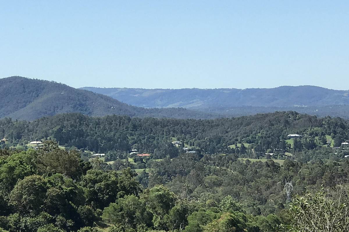
The view north from Belinda Place, Cedar Creek, next to Samford Valley, October 2022. Photo: Kerry Raymond, CC BY 4.0, via Wikimedia Commons.
Samford Valley (postcode 4520) is an acreage valley in the hills north-west of Brisbane, home to about 3,200 people in the City of Moreton Bay, about 26 km from the CBD and 4 km west of Samford Village, with the House Mountain Range to the north. Almost every home is a house, most on rural residential blocks, with the village shops, cafés and pub 4 minutes away. In October 2026 the median house value was about $2.1 million, and so few homes are rented that there is no official median rent.
Checked 16 November 2026. Every figure names its source, and the full list is under References at the end.
Samford Valley at a glance
| Samford Valley, QLD 4520 | Figure | Source |
|---|---|---|
| Council | City of Moreton Bay | Queensland Government |
| Distance to Brisbane CBD | About 23 km by road; 30 min drive off-peak, 35 min to 1 hr 20 min leaving at 7.30am | Google Maps, Nov 2026 |
| Population | 3,208 people, median age 45 | ABS Census 2021 |
| Median house value | $2,101,879 | Cotality, Oct 2026 |
| Median price, 4-bedroom house | $2,251,000 (14 sales, 22 days on market) | Domain, 12 months to Nov 2026 |
| House value growth | +6.5% over 12 months, +43.5% over 5 years, +125.0% since Oct 2017 | Cotality, Oct 2026 |
| Median rent | Not published: too few rentals | RTA, Sep quarter 2026 |
| Gross rental yield | Houses 2.9% | Cotality, Oct 2026 |
| Rental vacancy rate (postcode 4520) | 0.68% (2 of 292 rentals) | SQM Research, Oct 2026 |
| Homes | 99% separate houses; 85% have four or more bedrooms | ABS Census 2021 |
| State school catchments | Samford State School; Ferny Grove State High | Queensland Government, Jul 2026 |
| Public transport | Route 399 bus a few times a day; trains from Ferny Grove, 12 min by car | Translink; Google Maps |
| Nearest regional hub | Strathpine, 26 min (major regional activity centre) | SEQ Regional Plan 2009–2031 |
| Biggest build nearby | Samford Parklands Village Green upgrade ($4.4 million), 6 minutes away | City of Moreton Bay, 2025 |
| Reported offences | 29 in 12 months: about 9 per 1,000 residents (Moreton Bay: 73) | QPS Online Crime Map, Nov 2026 |
Is Samford Valley a good place to live?
Samford Valley suits buyers who want acreage, privacy and bush views 30 minutes from the CBD, with a village a few minutes away, and who can pay about $2 million. The trade-offs are driving for almost everything, a bushfire and water plan for the property, and a bus only a few times a day. At the 2021 Census, 99% of homes were separate houses and 85% had four or more bedrooms (Queensland: 39%), 48% were owned outright and 47% were being paid off, only 4% were rented, 54% of families were couples with children, and the median household income was $3,250 a week (Queensland: $1,675).
It is really three suburbs in one, and each comes with its own checks.
| Part of Samford Valley | What you get | What to check |
|---|---|---|
| The valley floor, along Mount Glorious Road | Flatter acreage with paddocks and creeks | The flood map near the creeks, the water supply and the septic system |
| The hills, up toward the ranges | Bigger, steeper blocks with views and bushland | The bushfire overlay, the driveway and road in, and the slope |
| The village edge, toward Samford Village | Smaller acreage closer to the shops, the school and the pub | Traffic on Samford Road and what can be built on the next lot |
What is the median house price in Samford Valley?
Samford Valley’s median house value was $2,101,879 at the end of October 2026, 6.5% higher than a year earlier, according to Cotality, while four- and five-bedroom houses sold for medians of $2.251 million and $2.315 million over the past year (Domain), against $1.728 million and $2.42 million in 2025 and $1.505 million and $1.765 million in 2022. Only two three-bedroom houses sold in the year.
Market trends by bedrooms (sales in the 12 months to November 2026, Domain):
| Home | Median price | Average days on market | Auction clearance | Sold in 12 months | 2022 median |
|---|---|---|---|---|---|
| 4-bedroom house | $2,251,000 | 22 | – | 14 | $1,505,000 |
| 5-bedroom house | $2,315,000 | 35 | – | 12 | $1,765,000 |
Growth over 12 months, 5, 9 and 17 years:
| Period | Houses | Source |
|---|---|---|
| 12 months to Oct 2026 | +6.5% | Cotality, median value |
| 5 years to Oct 2026 | +43.5% (7.5% a year) | Cotality, median value |
| 9 years, Oct 2017 to Oct 2026 | +125.0% (9.4% a year) | Cotality, median value |
| 17 years, May 2009 to Nov 2026 (postcode 4520) | $759,000 to $1,862,645, +145% (5.3% a year) | SQM Research, asking prices |
With about 40 sales a year, a few large properties move the medians: Cotality’s 12-month median sale price was $2.3 million on 37 sales in the year to August 2026, against $1.8 million on 53 a year earlier. The 17-year row covers the whole 4520 postcode, which includes Samford Village and the hinterland around it. A 20- or 30-year sales median needs paid sales data such as Pricefinder.
There is no reliable median rent for Samford Valley, because so few homes are rented: the Residential Tenancies Authority does not publish one, and at the 2021 Census only 4.4% of homes were rented (Queensland: 33%).
Rental yield and vacancy. Cotality puts Samford Valley’s gross yield for houses at 2.9%, based on its estimates of values and rents. SQM Research counted a vacancy rate of 0.68% for the whole 4520 postcode in October 2026, on just 2 vacant homes of 292 it tracks. If you are buying to rent out, ask a local property manager for recent leases on comparable acreage before you rely on any figure.
All of Samford Valley is in the Samford State School catchment, going by the Queensland Government’s July 2026 maps, and the Ferny Grove State High catchment. There is no school in the suburb itself.
| State school | Share of Samford Valley’s land in its catchment | 2025 score (Better Education) | Enrolment management plan |
|---|---|---|---|
| Samford State School, Samford Village | 100% | 93 | No |
| Ferny Grove State High School | 100% | 91 | Yes |
Ferny Grove State High enforces its catchment under an enrolment management plan, gazetted in July 2026 for 2,118 students, so it takes children from outside only when it has room; you prove the address with a current lease, a rates notice or an unconditional contract, plus a utility bill. Samford State School was not on the Department of Education’s list of schools with plans when we checked. Samford Valley Steiner School is nearby at Wights Mountain. The scores are Better Education’s, a third party’s ranking built on NAPLAN results.
Samford Valley is about 23 km north-west of the Brisbane CBD by road. Driving to King George Square takes about 30 minutes outside peak hour and 35 minutes to 1 hour 20 minutes leaving at 7.30am on a weekday, according to Google Maps. Buses are rare: the 7.05am route 399 bus and the Ferny Grove train reach the city in about an hour.
| From Samford Valley to | How | Typical time |
|---|---|---|
| Brisbane CBD (King George Square) | Car, leaving 7.30am weekday (23.5 km via Samford Road) | 35 min to 1 hr 20 min |
| Brisbane CBD | Car, off-peak | 30 min |
| Brisbane CBD | Bus 399 at 7.05am, then the Ferny Grove train | 1 hr 3 min |
| Samford Village (Main Street) | Car, off-peak | 4 min |
| Ferny Grove station | Car, off-peak | 12 min |
| Westfield Strathpine | Car, off-peak | 26 min |
| Brisbane Airport | Car, off-peak | 35 min |
| Sunshine Coast (Mooloolaba Beach) | Car, off-peak | 1 hr 15 min to 1 hr 25 min |
| Gold Coast (Surfers Paradise) | Car, off-peak | 1 hr 20 min to 1 hr 30 min |
On Census day 2021, 50% of workers drove to work, 3% took public transport, often after driving to the station, and 29% worked from home.
Strathpine is the closest regional hub in Moreton Bay, 26 minutes away. The South East Queensland Regional Plan 2009–2031 named Caboolture–Morayfield the city’s principal regional activity centre, with Strathpine, North Lakes and Redcliffe as major centres that “each provide a sub-regional focus for administration”.
Moreton Bay’s growth is planned for its urban areas and new estates. The 2017 ShapingSEQ background paper on growth set the city a benchmark of 88,300 more homes between 2016 and 2041, 48,200 in existing urban areas and 40,100 in new ones. Samford Valley is rural residential, which is why its blocks stay large.
The biggest build near Samford Valley is the $4.4 million Samford Parklands Village Green upgrade, 6 minutes away, a new community park for the Samford district.
- Why: to give the district a village green for gatherings and events.
- What it adds: open lawns for events, shaded picnic shelters, barbecues, a play space for children, accessible paths with valley views, and landscaped gardens with shade trees.
- Who: the City of Moreton Bay, with $2.2 million from the Australian Government’s Thriving Suburbs Program.
- Where it is up to: the council turned the first sod in December 2025 and expected construction to be completed by late 2026.
What it means if you buy in Samford Valley: a new park and event space 6 minutes away. Bigger change is unlikely here: the valley is rural residential, and there is no large project under way in it.
Brisbane, 30 minutes off-peak, is the nearest big job market, with Strathpine 26 minutes away and the village’s own shops and cafés 4 minutes.
- Jobs (2021 Census): professionals 32.3%, managers 20.1%, clerical and administrative workers 12.9%, technicians and trades workers 11.6%, community and personal service workers 8.3%.
- Top industries: hospitals 5.0%, computer system design 3.3%, primary schools 3.2%, state government administration 2.5% and cafes and restaurants 2.4%.
- Work patterns: 65.3% of adults were in the labour force and 4.0% were unemployed (Queensland 5.4%); 29% worked from home on Census day.
Samford Valley’s reported crime rate is far below Moreton Bay’s. It recorded 29 offences on the Queensland Police Service’s online crime map in the 12 months to 15 November 2026, about 9 for every 1,000 residents, against 73 per 1,000 across the City of Moreton Bay (34,795 offences).
| Offence type | Samford Valley, 12 months to 15 Nov 2026 |
|---|---|
| Other theft (not break-ins) | 10 |
| Traffic and related offences | 8 |
| Property damage | 4 |
| Assault | 2 |
| Unlawful entry (break-ins) | 2 |
| Good order offences | 2 |
| Fraud | 1 |
Police say the map’s figures are not official statistics and its locations show a general area; the rates use 2021 Census populations. With numbers this small, one or two incidents change the picture, so look up your own road on the map.
The bush, the lookouts and Samford Village’s main street are Samford Valley’s own, with most cafés and the pub 4 minutes away in the village. Ratings are Google’s, checked 16 November 2026.
Parks and the bush
- John Scott Park, Main Street, Samford Village, with a train-themed playground and a BMX track: 4.6 stars from 366 reviews.
- Samford Conservation Park: 4.6 from 405 reviews.
- Jollys Lookout, Mount Nebo Road, D’Aguilar National Park: 4.7 from 614 reviews.
- Undambi Reserve: 4.5 from 31 reviews.
Food and coffee
- Village Kitchen & Bar, Main Street, Samford Village: 4.8 from 230 reviews.
- Sophia’s Greek Kitchen, Main Street: 4.8 from 76 reviews.
- The Long Yard Larder, Main Street: 4.5 from 558 reviews.
- Latin Shack Cafe, Mount Glorious Road: 4.6 from 283 reviews.
- Café Lagarto, Mount Glorious Road: 4.3 from 551 reviews.
For kids
- John Scott Park, Samford Village: 4.6 from 366 reviews.
- City Chicks Farm, Mount Glorious Road: 4.3 from 335 reviews.
- Kumbartcho Sanctuary, Eatons Hill: 4.7 from 399 reviews.
For adults
- Jollys Lookout and the drive up to Mount Nebo and Mount Glorious.
- Village Kitchen & Bar, Samford Village: 4.8 from 230 reviews.
The local pub
The Samford Hotel, Main Street: rated 4.0 from 1,805 Google reviews, and our pick for a meal or a drink in Samford.
Check the bushfire overlay, the water and the road in before you talk price in Samford Valley. Acreage is easy to like, and these are the things that change a price.
- Bushfire. Moreton Bay’s bushfire hazard overlay applies wherever a lot is mapped, and it can affect what you build and how. Check the map and ask about the property’s fire breaks.
- Water and wastewater. Ask whether the home is on town water or tanks, how big the tanks are, and what septic or treatment system it has, then have it inspected.
- Flood. Get the council’s free Flood Check report for any lot near the creeks.
- Access. Drive the road in at peak time and after rain, and check the driveway’s condition and who maintains any shared access.
- Older homes. The QBCC says most homes built before 1990 contain some asbestos, so book building, pest and asbestos checks before you sign, and include any sheds and outbuildings.
IPS Buyer’s Agents works only for buyers and has bought across Moreton Bay for clients, including at Warner, Joyner and Mango Hill (see our client success stories). I live in Moreton Bay, in Warner, and Samford Valley is one of my favourite parts of it. On acreage, Zian and I check the bushfire map, the water and the septic before we talk price.
Comparing Samford Valley with Samford Village, Cedar Creek or Dayboro? Book a free call and tell us your brief. More local reports are on our Moreton Bay suburb reports page, and the bigger picture is in our Moreton Bay property market guide.
Is Samford Valley in the City of Moreton Bay?
Yes. Samford Valley is in the City of Moreton Bay, about 26 km north-west of the Brisbane CBD and 4 km west of Samford Village, so its rates, planning and flood maps come from Moreton Bay. Samford was split into Samford Village and Samford Valley in 1981.
What is Samford Valley’s postcode?
4520, which it shares with Samford Village, Cedar Creek, Highvale, Mount Glorious and other hinterland localities. Postcode figures, such as SQM Research’s vacancy rate and asking prices, cover all of them.
Is there a school in Samford Valley?
No. The nearest state primary is Samford State School in Samford Village, and the state high school is Ferny Grove State High. Samford Valley Steiner School is in Wights Mountain.
Can you catch a bus from Samford Valley?
Only a few times a day. Route 399 picks up along Mount Glorious Road, and its 7.05am service connects with the Ferny Grove train to reach the city at 8.08am. Most people drive to Ferny Grove station, 12 minutes away.
How many people live in Samford Valley?
About 3,200. The 2021 Census counted 3,208 people with a median age of 45 and 3.2 people per household, and 54% of families were couples with children (Queensland: 41%).
Why is there no median rent for Samford Valley?
Too few homes are rented. Only 4.4% were rented at the 2021 Census, so the Residential Tenancies Authority does not publish a median, and SQM Research counted 2 vacant rentals among 292 in the whole 4520 postcode in October 2026.
How many homes sell in Samford Valley each year?
About 40. Cotality counted 37 house sales in the 12 months to August 2026 at a median of $2.3 million, down from 53 sales a year earlier.
How far is Samford Valley from Brisbane Airport?
About 35 minutes by car (31.6 km via Samford Road) outside peak times, according to Google Maps.
- Cotality via OnTheHouse: Samford Valley suburb profile (median values, growth, yields, sales), as at 31 October 2026
- Domain: Samford Valley suburb profile, market trends by bedrooms, checked 16 November 2026
- Residential Tenancies Authority: median rents by suburb, September quarter 2026
- SQM Research: vacancy rates and asking prices for postcode 4520
- Australian Bureau of Statistics: 2021 Census QuickStats, Samford Valley
- Queensland Government: state school catchments, July 2026
- Department of Education: Ferny Grove State High School enrolment management plan
- Better Education: 2025 school scores
- Queensland Police Service: Online Crime Map, 16 November 2025 to 15 November 2026
- Queensland Government: South East Queensland Regional Plan 2009–2031, Part C (Moreton Bay)
- Queensland Government: ShapingSEQ 2017, Background paper 1: Grow, Table 9 (dwelling supply benchmarks to 2041)
- City of Moreton Bay: Breaking ground on Samford Parklands Village Green Park Upgrade, 5 December 2025
- City of Moreton Bay: bushfire hazard overlay
- City of Moreton Bay: Flood Check property report
- Wikipedia: Samford Valley, Queensland
- Google Maps: drive and transit times and ratings, checked 16 November 2026