
Kingston QLD Suburb Profile 2026: Land Values, Rent, Schools and Lifestyle

By Tim AllenBuyer’s Agent and Director, IPS Buyer’s Agents
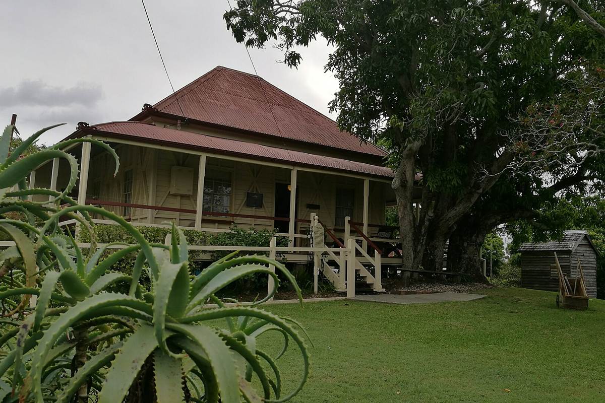
Mayes Cottage, a heritage-listed house from about 1887, Kingston, 2017. Photo: Ash.david, CC BY-SA 4.0, via Wikimedia Commons.
Kingston (postcode 4114) is a Logan suburb about 28 km south of the Brisbane CBD by road, home to 10,506 people at the 2021 Census, on the Beenleigh railway line next to Logan Central. It is named after Charles and Harriet Kingston, who lived in the district in the late 1800s and are buried in its heritage-listed pioneer cemetery; the Kingston Butter Factory opened in 1907, made butter until 1983 and is now a cultural precinct. At the Queensland Valuer-General’s 2025 valuation the median value of residential land was $375,000, up 15.4% in two years and level with Logan’s median, and homes were renting for $580 a week in September 2026.
Checked 21 November 2026. Every figure names its source, and the full list is under References at the end. Prices come from the Queensland Valuer-General’s land valuations, which the Queensland Government publishes for anyone to use.
Kingston at a glance
| Kingston, QLD 4114 | Figure | Source |
|---|---|---|
| Council | City of Logan | Queensland Government |
| Distance to Brisbane CBD | About 28 km by road; 24 to 28 min drive off-peak, 35 min to 1 hr 10 min leaving at 7.30am | Google Maps, Nov 2026 |
| Population | 10,506 people, median age 32 | ABS Census 2021 |
| Median value of residential land | $375,000 at 1 October 2024, up 15.4% in two years (3,017 properties) | Queensland Valuer-General, 2025 valuation |
| Against Logan | Level with the city median of $375,000 (up 19.1%) | Queensland Valuer-General, 2025 valuation |
| Median rent, all homes | $580 a week (3-bed house $590, 4-bed $650, 2-bed unit $500) | RTA, Sep quarter 2026 |
| Rent since 2017 | All homes up from $330 to $580 a week (+76%) | RTA, September quarters |
| Homes rented | 51% (Queensland 33%) | ABS Census 2021 |
| Homes | 83% separate houses, 15% townhouses and semis; 60% have three bedrooms | ABS Census 2021 |
| State school catchments | Kingston State School for most; Kingston State College or Woodridge State High School | Queensland Government, Jul 2026 |
| Public transport | Kingston station (Beenleigh line); bus 561 about 58 min door to door to the CBD | Google Maps, Nov 2026 |
| Nearest hub | Logan Central, 6 min (a major regional activity centre); Logan Hospital 7 min | SEQ Regional Plan 2009–2031 |
| Biggest build | Kingston station precinct upgrade, part of Logan and Gold Coast Faster Rail: in pre-construction | Transport and Main Roads |
| Reported offences | 2,006 in 12 months: about 191 per 1,000 residents (Logan: 111) | QPS Online Crime Map, Nov 2026 |
| Next land valuation | Logan is in the 2027 program: new values at 1 October 2026 | Queensland Valuer-General |
Is Kingston a good place to live?
Is Kingston a good suburb? For first-home buyers and investors who want a house on the Beenleigh line at about Logan’s median land value, it is worth a look: Logan Central’s shops are 6 minutes away, Logan Hospital 7 and the CBD 24 to 28 minutes outside peak hour, and the station is being rebuilt. The trade-offs are a reported crime rate well above Logan’s, half the homes rented, older houses that often need work, and an old mine site that caused a toxic waste scare in the 1980s. At the 2021 Census 83% of homes were separate houses, 60% had three bedrooms and the median age was 32.
It is really three places in one, and each comes with its own checks.
| Part of Kingston | What you get | What to check |
|---|---|---|
| Around the station and the Butter Factory | Older houses and townhouses near Kingston station, the Butter Factory and Kingston Road | Rail noise, the station works and the street |
| The established streets | Low-set brick and timber houses from the 1960s on, many of them rented | The building report, the wiring and plumbing, and the contaminated land registers near Mount Taylor |
| The south near Scrubby Creek | Houses near the creek and the Logan Motorway on the suburb’s southern edge | The flood map, motorway noise and the way in and out |
What is the median house price in Kingston?
We use only free, open government data in this profile, and that has no current median sale price for Kingston. The official open measure is the Queensland Valuer-General’s median value of residential land: $375,000 at 1 October 2024, up 15.4% from $325,000 two years earlier, across 3,017 properties. That is level with Logan’s median of $375,000, which rose 19.1%.
Median value of residential land (Queensland Valuer-General, 2025 valuation):
| Area | Median at 1 Oct 2022 | Median at 1 Oct 2024 | Change | Properties |
|---|---|---|---|---|
| Kingston | $325,000 | $375,000 | +15.4% | 3,017 |
| Berrinba | $315,000 | $390,000 | +23.8% | 636 |
| Logan Central | $310,000 | $355,000 | +14.5% | 1,551 |
| Loganlea | $295,000 | $370,000 | +25.4% | 2,339 |
| Marsden | $325,000 | $395,000 | +21.5% | 3,744 |
| Meadowbrook | $400,000 | $495,000 | +23.8% | 850 |
| Slacks Creek | $325,000 | $375,000 | +15.4% | 3,012 |
| Waterford West | $325,000 | $350,000 | +7.7% | 1,606 |
| All of Logan | – | $375,000 | +19.1% | – |
A land valuation is the Valuer-General’s estimate of what the land alone was worth on the valuation date, without the house. It is not a sale price, and these figures are now two years old: Logan was last valued at 1 October 2024. It is in the 2027 program, so new values, set at 1 October 2026, will be issued in 2027; councils use them to set rates and the state uses them for land tax. Kingston’s land is valued level with Slacks Creek’s and Logan’s median, above Logan Central’s and Waterford West’s and below Marsden’s and Meadowbrook’s, and it rose less than Logan’s median over the two years, so compare streets and blocks, not just suburb medians. For what homes have actually sold for, compare recent sales on the property portals, or ask us.
The median rent on new leases for all homes in Kingston was $580 a week in the September quarter 2026, up from $550 a year earlier and $330 in September 2017, according to the Residential Tenancies Authority’s bond data: up 76% in nine years.
| September quarter | All homes, Kingston (median weekly rent) |
|---|---|
| 2017 | $330 |
| 2019 | $320 |
| 2021 | $350 |
| 2022 | $410 |
| 2023 | $460 |
| 2024 | $500 |
| 2025 | $550 |
| 2026 | $580 |
By type in the September quarter 2026: three-bedroom houses $590 a week, four-bedroom houses $650 and two-bedroom units $500 (RTA).
Who rents. At the 2021 Census 51% of Kingston’s homes were rented, against 33% across Queensland; 25% were being paid off and 21% were owned outright (Queensland: 34% and 29%).
Kingston is split between primary catchments, going by the Queensland Government’s July 2026 maps: Kingston State School’s covers about 65% of its area, Berrinba East State School’s 15% and Mabel Park State School’s 12%, with smaller parts in Woodridge’s, Burrowes’ and Marsden’s. For high school, 59% is in Kingston State College’s catchment, 28% in Woodridge State High School’s and 12% in Mabel Park State High School’s.
| State school | Share of Kingston in its catchment | Enrolment management plan |
|---|---|---|
| Kingston State School | 65% | Yes |
| Berrinba East State School | 15% | Yes |
| Mabel Park State School | 12% | Yes |
| Woodridge State School | 5% | Yes |
| Kingston State College | 59% | No |
| Woodridge State High School | 28% | Yes |
| Mabel Park State High School | 12% | Yes |
The shares are of the locality’s mapped area, not homes, so put the exact address into the Queensland Government’s EdMap before you rely on a catchment. All of these schools except Kingston State College enforce their catchments under enrolment management plans, so they take children from outside only when they have room; you prove the address with a current lease, a rates notice or an unconditional contract, plus a utility bill. Kingston State College was not on the Department of Education’s list of schools with plans when we checked; it opened in 1977 as Kingston State High School, and Kingston State School opened in 1912. Groves Christian College, a private Prep to Year 12 school, is on Laughlin Street.
Kingston is about 28 km south of the Brisbane CBD by road. Driving to King George Square takes about 24 to 28 minutes outside peak hour and 35 minutes to 1 hour 10 minutes leaving at 7.30am on a weekday. Kingston station is on the Beenleigh line: on a weekday morning, bus 561 took about 58 minutes door to door and the train about 1 hour 8 minutes.
| From Kingston to | How | Typical time |
|---|---|---|
| Brisbane CBD (King George Square) | Car, leaving 7.30am weekday | 35 min to 1 hr 10 min |
| Brisbane CBD | Car, off-peak (28.2 km) | 24 to 28 min |
| Brisbane CBD | Bus 561, leaving 7.37am | 58 min door to door |
| Brisbane CBD | Walk and train from Kingston station, leaving 7.36am | 1 hr 8 min door to door |
| Logan Central Plaza | Car, off-peak | 6 min |
| Logan Hospital | Car, off-peak | 7 min |
| Logan Hyperdome | Car, off-peak | 14 min |
| Brisbane Airport | Car, off-peak | 30 min |
| Gold Coast (Surfers Paradise) | Car, off-peak | 40 to 50 min |
| Sunshine Coast (Mooloolaba Beach) | Car, off-peak | 1 hr 30 min |
On Census day 2021, 76% of Kingston’s workers drove or rode in a car to work, 4% took public transport (Queensland: 4%) and 6% worked from home (Queensland: 14%).
Logan Central, next door, is Kingston’s hub: Logan Central Plaza is 6 minutes away and Logan Hospital in Meadowbrook 7. The South East Queensland Regional Plan 2009–2031 named Springwood and Beenleigh Logan’s two principal regional activity centres, with Logan Central, Browns Plains and the Logan Hyperdome, 14 minutes away, among its major ones, and Meadowbrook its health, education and technology employment area.
Logan’s growth is mostly in new estates further south and west. The 2017 ShapingSEQ background paper on growth set Logan a benchmark of 89,900 more homes between 2016 and 2041, 70,000 of them in new expansion areas such as Flagstone, Yarrabilba and Park Ridge, so established suburbs like Kingston change slowly; the rail upgrade is the big change here.
The biggest build in Kingston is the Kingston station precinct upgrade, part of Logan and Gold Coast Faster Rail, which will give the 20 km line between Kuraby and Beenleigh four tracks instead of two, for more trains, more reliably.
- What it adds: a station moved away from the Kingston Road bridge, so the bridge does not need rebuilding; entries and bus stops off Milky Way with a better link to the Kingston Butter Factory; park ’n’ rides on both sides; a pedestrian overpass to the platforms; lighting and CCTV; and a secure bike enclosure.
- Where it is up to: pre-construction: the ActivUs Alliance has developed the design after community consultation, and Transport and Main Roads has published a summary of the feedback. The whole project has $5.75 billion, shared equally by the Australian and Queensland governments.
- Next door: Loganlea station and its park ’n’ ride are being moved closer to Logan Hospital, and that work is under construction; see our Meadowbrook profile.
What it means if you buy in Kingston: more frequent, more reliable trains to Brisbane and the Gold Coast once it is built, and years of rail works through Kingston while it is. If you buy near the line or the station, check how the new tracks, car parks and entries change the street.
Logan Central, Logan Hospital and the industrial estates at Berrinba and Crestmead are the nearest job centres, and the CBD is 24 to 28 minutes away off-peak. Labourers were Kingston’s biggest group of workers at the 2021 Census, followed by machinery operators and drivers.
- Jobs (2021 Census): labourers 20.2% (Queensland 10.1%), machinery operators and drivers 16.7% (Queensland 6.8%), technicians and trades workers 14.4%, community and personal service workers 14.3% and clerical and administrative workers 10.1%.
- Top industries: supermarkets 4.0%, takeaway food 3.5%, social assistance 3.4%, aged care 3.1% and hospitals 2.6%.
- Work patterns: 46.9% of adults were in the labour force (Queensland 61.6%), 13.3% were unemployed (Queensland 5.4%) and the median household income was $1,181 a week.
Kingston’s reported crime rate is well above Logan’s. It recorded 2,006 offences on the Queensland Police Service’s online crime map in the 12 months to 19 November 2026, about 191 for every 1,000 residents, against 111 per 1,000 across the city. “Other theft”, the group that includes shoplifting, was the largest, at 831, followed by drug offences (283) and assault (169).
| Offence type | Kingston, 12 months to 19 Nov 2026 |
|---|---|
| Other theft (not break-ins) | 831 |
| Drug offences | 283 |
| Assault | 169 |
| Other | 161 |
| Property damage | 151 |
| Good order offences | 97 |
| Unlawful entry (break-ins) | 94 |
| Traffic and related offences | 94 |
| Unlawful use of a motor vehicle | 74 |
| Other offences against the person | 52 |
Police say the map’s figures are not official statistics and its locations show a general area; the rates use 2021 Census populations, and the shops on Kingston Road, the station and Logan Central next door draw offences by people who do not live here. There were 94 break-ins in the year, about 9 per 1,000 residents. Before you buy, look up your own street on the map.
Kingston is about the Butter Factory, its parks and playgrounds, and the food along Kingston Road and in Logan Central next door. Ratings are Google’s, checked 21 November 2026.
Parks
- Logan Gardens, Civic Parade, Logan Central: 4.4 stars from 1,089 reviews.
- Gould Adams Park, Kingston Road: 4.3 from 515 reviews.
- ANZAC Park, Jacaranda Avenue: 4.0 from 61 reviews.
Food and coffee
- Devon Pixies, a cafe at the Butter Factory on Jacaranda Avenue: 4.7 from 349 reviews.
- Punjabi Bytes, Kingston Road: 4.8 from 63 reviews.
- Shezan Indian, Kingston Road: 4.7 from 208 reviews.
- Dawg Boys, Juers Street: 4.6 from 233 reviews.
- Kickin’ Inn, Wembley Road, Logan Central: 4.8 from 6,521 reviews.
For kids
- JJ Smith Park, Princess Street: 4.1 from 170 reviews.
- Mabel Park, Paradise Road: 4.2 from 156 reviews.
- Sturdee Park, Station Road: 4.3 from 88 reviews.
For adults
- Kingston Butter Factory Cultural Precinct, for shows and events, Jacaranda Avenue: 4.3 from 227 reviews.
- Monkey Tree Brewing Co., a brewery on Aranda Street, Slacks Creek: 4.9 from 229 reviews.
- Diggers Services Club, Blackwood Road, Logan Central: 4.2 from 958 reviews.
The local pub
The Chatswood Hills Tavern, Magellan Road, Springwood, 8 to 10 minutes away: Kingston has no pub of its own, and this one, with a bistro and a beer garden, is rated 4.4 from 2,241 Google reviews; our pick for a meal or a drink close to home, as it is for Springwood.
Check the land, the street and the building report before you talk price in Kingston. These are the things that change a price here.
- Contaminated land. In the 1980s, waste dumped in the old Mount Taylor gold mine, at Queens and Kingston roads, seeped into nearby gardens; the state bought 46 homes and sealed the site in 1991, and it is now parkland. Search the Environmental Management and Contaminated Land registers for any address nearby.
- Flood. Streets near Scrubby Creek, on the southern edge, can be flood-prone. Check the City of Logan’s flood mapping for the exact address.
- The street. Rentals and reported crime vary from street to street. Look up the street on the police crime map, and visit at night as well as by day.
- The rail works. If you buy near the line or the station, look at Transport and Main Roads’ plans for the new tracks, car parks and entries, and expect works for some years.
- Condition. Many houses date from the 1960s on. Book a building and pest inspection, and check the wiring, the plumbing and any unapproved extensions.
IPS Buyer’s Agents works only for buyers, across Logan and the rest of South East Queensland. In Kingston, Zian and I check the contaminated land registers, the flood map, the street and the building report before we talk price.
Comparing Kingston with Marsden, Slacks Creek or Loganlea? Book a free call and tell us your brief. See how we work as a Logan buyer’s agent, our Marsden and Meadowbrook profiles and our other Logan suburb reports.
Is Kingston a good suburb?
For first-home buyers and investors who want a house on the Beenleigh line at about Logan’s median land value, it is worth a look: Logan Central’s shops are 6 minutes away, Logan Hospital 7 and the CBD 24 to 28 minutes outside peak hour, and the station is being rebuilt. The trade-offs are a reported crime rate well above Logan’s, half the homes rented, older houses that often need work, and an old mine site that caused a toxic waste scare in the 1980s.
What is the land value in Kingston?
The Queensland Valuer-General put the median value of residential land in Kingston at $375,000 at 1 October 2024, up 15.4% in two years, across 3,017 properties: level with Logan’s median of $375,000. Logan is in the 2027 valuation program, with new values at 1 October 2026.
How much is rent in Kingston?
About $580 a week for all homes on new leases in the September quarter 2026: $590 for a three-bedroom house, $650 for a four-bedroom house and $500 for a two-bedroom unit (Residential Tenancies Authority). Rents for all homes are up 76% since 2017, when the median was $330.
Which school catchment is Kingston in?
Kingston is split between primary catchments: Kingston State School’s covers about 65% of it, Berrinba East’s 15% and Mabel Park’s 12%. For high school, 59% is in Kingston State College’s catchment, 28% in Woodridge State High School’s and 12% in Mabel Park State High School’s. Check the exact address on EdMap.
How far is Kingston from Brisbane?
About 28 km: 24 to 28 minutes by car to the CBD outside peak hour and 35 minutes to 1 hour 10 minutes leaving at 7.30am. Kingston station is on the Beenleigh line; bus 561 took about 58 minutes door to door and the train about 1 hour 8 minutes. Logan Hospital is 7 minutes away, Brisbane Airport 30 and Surfers Paradise 40 to 50.
Is Kingston safe?
Its reported crime rate is well above Logan’s: 2,006 offences on the police crime map in the 12 months to 19 November 2026, about 191 per 1,000 residents against 111 across the city. Thefts were the largest group, at 831, and there were 94 break-ins, about 9 per 1,000 residents.
What is being built near Kingston?
Kingston station is being rebuilt as part of Logan and Gold Coast Faster Rail, which will give the Kuraby to Beenleigh line four tracks: the station moves away from the Kingston Road bridge, with park ’n’ rides on both sides and a link to the Butter Factory. It is in pre-construction; next door, Loganlea station is already being moved.
What happened at Mount Taylor in Kingston?
In the 1980s, waste dumped in the old Mount Taylor gold mine seeped into nearby gardens. The state bought 46 homes and sealed and landscaped the site in 1991, and it is now the Mount Taylor Parklands. If you buy nearby, search the Environmental Management and Contaminated Land registers for the address.
- Queensland Valuer-General: Land valuation update 2025, Logan City (median value of residential land by locality, valuation date 1 October 2024), from the past valuation overviews
- Queensland Valuer-General: land valuations in 2027
- Residential Tenancies Authority: median rents by suburb, September quarters 2017 to 2026
- Australian Bureau of Statistics: 2021 Census QuickStats, Kingston (Qld)
- Queensland Government: state school catchments, July 2026
- Department of Education: school enrolment management plans
- Queensland Police Service: Online Crime Map, 20 November 2025 to 19 November 2026
- Queensland Government: South East Queensland Regional Plan 2009–2031, Part C (Logan)
- Queensland Government: ShapingSEQ 2017, Background paper 1: Grow, Table 9 (dwelling supply benchmarks to 2041)
- Transport and Main Roads: Kingston station precinct upgrade
- Transport and Main Roads: Logan and Gold Coast Faster Rail
- Wikipedia: Kingston, Queensland
- Google Maps: drive times and ratings, checked 20 and 21 November 2026