
Currimundi QLD Suburb Profile 2026: Land Values, Rent, Schools and Lifestyle

By Tim AllenBuyer’s Agent and Director, IPS Buyer’s Agents
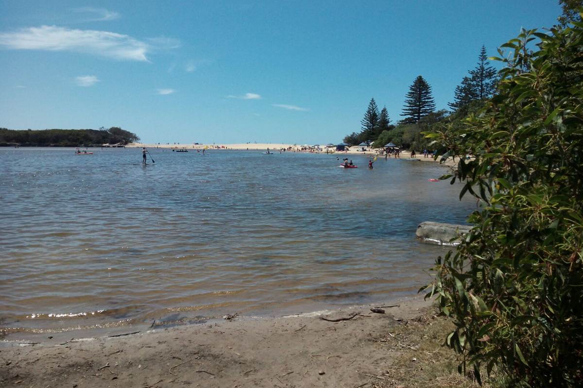
Currimundi Lake, October 2016. Photo: Michael Bednarek, CC BY-SA 4.0, via Wikimedia Commons.
Currimundi (postcode 4551) is a coastal suburb at the northern end of Caloundra on the Sunshine Coast, home to 6,570 people at the 2021 Census and about 92 km from the Brisbane CBD by road. Its name comes from the local Aboriginal name for the area, Garamandah or Girramundi, meaning place of flying foxes, and it wraps around Currimundi Lake, a saltwater lake beside the beach with a conservation park to its north. At the Queensland Valuer-General’s 2026 valuation the median value of residential land was $560,000, up 25.8% in two years, and homes were renting for $760 a week in September 2026.
Checked 20 November 2026. Every figure names its source, and the full list is under References at the end. Prices come from the Queensland Valuer-General’s land valuations, which the Queensland Government publishes for anyone to use.
Currimundi at a glance
| Currimundi, QLD 4551 | Figure | Source |
|---|---|---|
| Council | Sunshine Coast Council | Queensland Government |
| Distance to Brisbane CBD | About 92 km by road; 1 hr 5 min to 1 hr 20 min drive off-peak, 1 hr 20 min to 2 hr leaving at 7.30am | Google Maps, Nov 2026 |
| Population | 6,570 people, median age 45 | ABS Census 2021 |
| Median value of residential land | $560,000 at 1 October 2025, up 25.8% in two years (2,331 properties) | Queensland Valuer-General, 2026 valuation |
| Against the Sunshine Coast | About level with the council median of $570,000 (up 27%) | Queensland Valuer-General, 2026 valuation |
| Median rent, all homes | $760 a week (3-bed house $780) | RTA, Sep quarter 2026 |
| Rent since 2017 | All homes up from $450 to $760 a week (+69%) | RTA, September quarters |
| Homes rented | 25% (Queensland 33%) | ABS Census 2021 |
| Homes | 82% separate houses, 17% townhouses and duplexes; 37% have four or more bedrooms | ABS Census 2021 |
| State school catchments | Mostly Talara Primary College; Meridan State College | Queensland Government, Jul 2026 |
| Public transport | Buses on Nicklin Way: about 2 hr 40 min to the CBD with the train | Google Maps, Nov 2026 |
| Nearest hub | Kawana, next door: Sunshine Coast University Hospital 7 min (Kawana a major regional activity centre) | SEQ Regional Plan 2009–2031 |
| Biggest build nearby | Caloundra Transport Corridor Upgrade: a new road into Caloundra, due mid-2028 | Sunshine Coast Council |
| Reported offences | 289 in 12 months: about 44 per 1,000 residents (Sunshine Coast: 50) | QPS Online Crime Map, Nov 2026 |
| Next land valuation | The Sunshine Coast is not in the 2027 program | Queensland Valuer-General |
Is Currimundi a good place to live?
Currimundi suits families and retirees who want a quiet beach suburb with a lake for paddling, a bushland conservation park and the coast’s main hospital 7 minutes away, at a land value about level with the Sunshine Coast median. The trade-offs are a long drive to Brisbane, public transport that barely works for it, flood and storm tide risks near the lake and the beach, and traffic on Nicklin Way. At the 2021 Census 82% of homes were separate houses, 39% were owned outright, only 25% were rented and the median age was 45.
It is really three places in one, and each comes with its own checks.
| Part of Currimundi | What you get | What to check |
|---|---|---|
| Around the lake and the beach | Houses and townhouses near Currimundi Lake, the surf beach and the conservation park | The flood and storm tide maps, coastal erosion and the building report |
| The streets west of Nicklin Way | Brick houses from the 1970s on, on standard blocks near Talara Primary College | The school catchment, traffic noise near Nicklin Way and any renovations |
| Townhouses and duplexes | Duplexes and small townhouse complexes, about one home in six | The body corporate records, or the agreement with the owner of the other half |
What is the median house price in Currimundi?
We use only free, open government data in this profile, and that has no current median sale price for Currimundi. The official open measure is the Queensland Valuer-General’s median value of residential land: $560,000 at 1 October 2025, up 25.8% from $445,000 two years earlier, across 2,331 properties. That is about the same as the Sunshine Coast median of $570,000, which rose 27%.
Median value of residential land (Queensland Valuer-General, 2026 valuation):
| Area | Median at 1 Oct 2023 | Median at 1 Oct 2025 | Change | Properties |
|---|---|---|---|---|
| Currimundi | $445,000 | $560,000 | +25.8% | 2,331 |
| Dicky Beach | $700,000 | $850,000 | +21.4% | 685 |
| Wurtulla | $660,000 | $730,000 | +10.6% | 2,105 |
| Battery Hill | $570,000 | $690,000 | +21.1% | 812 |
| Birtinya | $510,000 | $510,000 | 0% | 878 |
| Aroona | $445,000 | $560,000 | +25.8% | 1,269 |
| Little Mountain | $430,000 | $560,000 | +30.2% | 2,743 |
| All of the Sunshine Coast (residential) | – | $570,000 | +27% | – |
A land valuation is the Valuer-General’s estimate of what the land alone was worth on the valuation date, without the house. It is not a sale price, and it is months old by the time it is issued; councils use it to set rates and the state uses it for land tax. The Sunshine Coast was revalued at 1 October 2025 and is not in the 2027 program. Beachside Dicky Beach and Wurtulla are well above Currimundi, and Birtinya’s median did not move at all, so compare streets and blocks, not just suburb medians. For what homes have actually sold for, compare recent sales on the property portals, or ask us.
The median rent on new leases for all homes in Currimundi was $760 a week in the September quarter 2026, up from $730 a year earlier and $450 in September 2017, according to the Residential Tenancies Authority’s bond data: a 69% rise in nine years.
| September quarter | All homes, Currimundi (median weekly rent) |
|---|---|
| 2017 | $450 |
| 2019 | $450 |
| 2021 | $555 |
| 2022 | $630 |
| 2023 | $600 |
| 2024 | $640 |
| 2025 | $730 |
| 2026 | $760 |
By type: three-bedroom houses $780 a week in the September quarter 2026; four-bedroom houses were $885 in the June quarter, the last quarter with enough new leases for a median (RTA).
Who rents. At the 2021 Census 25% of Currimundi’s homes were rented, against 33% across Queensland; 34% were being paid off and 39% were owned outright (Queensland: 34% and 29%).
Most of Currimundi is in the Talara Primary College catchment, going by the Queensland Government’s July 2026 maps, and the rest in Currimundi State School’s. For high school, almost all of it is in Meridan State College’s catchment, with a small part in Caloundra State High School’s.
| State school | Share of Currimundi in its catchment | Enrolment management plan |
|---|---|---|
| Talara Primary College | 70% | Yes |
| Currimundi State School | 30% | Yes |
| Meridan State College | 96% | No |
| Caloundra State High School | 4% | Yes |
The shares are of the locality’s mapped area, not homes, so put the exact address into the Queensland Government’s EdMap before you rely on a catchment. Talara Primary College, Currimundi State School and Caloundra State High School enforce their catchments under enrolment management plans, so they take children from outside only when they have room; you prove the address with a current lease, a rates notice or an unconditional contract, plus a utility bill. Meridan State College was not on the Department of Education’s list of schools with plans when we checked. Currimundi State School opened in 1977 and Talara Primary College in 1998.
Currimundi is about 92 km north of the Brisbane CBD by road. Driving to King George Square takes about 1 hour 5 minutes to 1 hour 20 minutes outside peak hour and 1 hour 20 minutes to 2 hours leaving at 7.30am on a weekday. Public transport is slow: on a weekday morning every trip leaving after 7.30am reached the city at 11.02am, the quickest on two buses and the train in 2 hours 36 minutes.
| From Currimundi to | How | Typical time |
|---|---|---|
| Brisbane CBD (King George Square) | Car, leaving 7.30am weekday (101 km) | 1 hr 20 min to 2 hr |
| Brisbane CBD | Car, off-peak (91.9 km) | 1 hr 5 min to 1 hr 20 min |
| Brisbane CBD | Two buses and the train, leaving 8.26am | 2 hr 36 min door to door |
| Sunshine Coast University Hospital | Car, off-peak | 7 min |
| Kawana Shoppingworld | Car, off-peak | 12 min |
| Mooloolaba Beach | Car, off-peak | 18 to 22 min |
| Brisbane Airport | Car, off-peak | 1 hr to 1 hr 10 min |
| Gold Coast (Surfers Paradise) | Car, off-peak | 1 hr 50 min to 2 hr 10 min |
On Census day 2021, 70% of Currimundi’s workers drove or rode in a car to work, 1% took public transport (Queensland: 4%), 2% rode a bike and 11% worked from home (Queensland: 14%).
Kawana, next door, is Currimundi’s hub: Sunshine Coast University Hospital in Birtinya is 7 minutes away and Kawana Shoppingworld 12. The South East Queensland Regional Plan 2009–2031 named Kawana and Caloundra two of the Sunshine Coast’s major regional activity centres, with Noosa, Nambour, Caloundra South and Sippy Downs, and Maroochydore the coast’s only principal one.
The 2017 ShapingSEQ background paper on growth set the Sunshine Coast a benchmark of 87,000 more homes between 2016 and 2041, 53,700 of them in existing urban areas. Currimundi is fully built, so it changes slowly; most of the growth nearby is at Birtinya and in the new estates of Caloundra South.
The biggest build near Currimundi is Sunshine Coast Council’s Caloundra Transport Corridor Upgrade, a new 1.6 km road linking Nicklin Way to Omrah Avenue, as another way into the Caloundra CBD.
- Why: to ease congestion at the Caloundra Road, Nicklin Way and Pelican Waters Boulevard roundabout and meet the traffic expected over the next 10 years, with flow-on benefits for local roads in Currimundi, Dicky Beach and Moffat Beach, the council says.
- What it adds: an extension of Third Avenue from Nicklin Way to Arthur Street with two lanes each way, new traffic lights, a walking and cycling underpass at West Terrace and a separated two-way cycle track.
- Who and when: the council is building it with contractor SEE Civil, and Transport and Main Roads co-funds the Nicklin Way section; construction began in September 2026 and is due to finish in mid-2028.
- Next door: Stockland’s plan for a bigger town centre at Birtinya, in our Birtinya suburb profile.
What it means if you buy in Currimundi: roadworks on the way into Caloundra until mid-2028, then an easier drive south. Currimundi itself is likely to look much the same in five years.
Sunshine Coast University Hospital, 7 minutes away, and the Kawana and Caloundra centres are the nearest big employers, and hospitals were Currimundi residents’ biggest employer at the 2021 Census. 11% worked from home (Queensland: 14%).
- Jobs (2021 Census): professionals 19.3%, technicians and trades workers 16.9% (Queensland 13.7%), community and personal service workers 14.8% (Queensland 12.3%), clerical and administrative workers 12.0% and labourers 10.4%.
- Top industries: hospitals 6.3% (Queensland 5.0%), aged care 3.5% (Queensland 2.2%), primary schools 3.1%, supermarkets 3.0% and cafes and restaurants 2.5%.
- Work patterns: 57.9% of adults were in the labour force (Queensland 61.6%), 4.6% were unemployed (Queensland 5.4%) and the median household income was $1,467 a week.
Currimundi’s reported crime rate is a little below the Sunshine Coast’s. It recorded 289 offences on the Queensland Police Service’s online crime map in the 12 months to 19 November 2026, about 44 for every 1,000 residents, against 50 per 1,000 across the Sunshine Coast. Thefts were the largest group, at 95.
| Offence type | Currimundi, 12 months to 19 Nov 2026 |
|---|---|
| Other theft (not break-ins) | 95 |
| Drug offences | 56 |
| Traffic and related offences | 34 |
| Property damage | 25 |
| Unlawful entry (break-ins) | 18 |
| Good order offences | 16 |
| Other | 11 |
| Unlawful use of a motor vehicle | 9 |
| Fraud | 9 |
| Trespassing and vagrancy | 9 |
| Assault | 7 |
Police say the map’s figures are not official statistics and its locations show a general area; the rates use 2021 Census populations. There were 18 break-ins in the year, about 3 per 1,000 residents. Before you buy, look up your own street on the map.
Currimundi is about the lake, the beach and the conservation park, with Dicky Beach and Caloundra’s cafes a few minutes south. Ratings are Google’s, checked 20 November 2026.
The lake, the beach and the bush
- Currimundi Lake (Kathleen McArthur) Conservation Park, the bushland north of the lake: 4.6 stars from 274 reviews.
- Cliff Hargreaves Park, on the lake at Westaway Parade: 4.6 from 75 reviews.
- Grahame Stewart Park, Croydon Avenue: 4.6 from 394 reviews.
- The off-leash dog area on Currimundi Beach, from Buderim Street: 4.8 from 252 reviews.
Food and coffee
- Penny G’s Coffee, Lomandra Drive: 4.8 from 58 reviews.
- Coco’s By The Lake, Westaway Parade: 4.2 from 861 reviews.
- Wurtulla Seafoods, fish and chips on Nicklin Way: 4.8 from 239 reviews.
- Curry Dhaba, Indian food on Beerburrum Street: 4.7 from 69 reviews.
For kids
- The playground at Grahame Stewart Park: 4.8 from 11 reviews.
- The calm water of Currimundi Lake for paddling and kayaking.
For adults
- Dicky Beach Surf Club, next door on Coochin Street: 4.3 from 1,712 reviews.
- Moffat Beach Brewing Co., Seaview Terrace, Moffat Beach: 4.3 from 720 reviews.
The local pub
Your Mates Brewing Co., 41 Technology Drive, Warana, a few minutes north: a brewery bar rated 4.7 from 1,198 Google reviews, and our pick for a drink near home. The suburb’s own pub, the Currimundi Hotel, is rated 3.9 from 903.
Check the flood and storm tide maps, the coastline and the building report before you talk price in Currimundi. These are the things that change a price here.
- Flood and storm tide. Homes near Currimundi Lake, its creeks and the beach can be affected by flooding and storm tide. Check Sunshine Coast Council’s flood mapping for the exact address.
- Coastal erosion. For a home near the beach, check the council’s coastal hazard mapping and the state of the dunes.
- Townhouses and duplexes. About one home in six is a townhouse or duplex: read the body corporate records, or the agreement with the owner of the other half.
- Traffic. Homes near Nicklin Way hear it, and the road into Caloundra will have works until mid-2028. Visit at peak hour.
- Condition. Many houses date from the 1970s and 1980s. Book a building and pest inspection, and check for salt damage near the beach.
IPS Buyer’s Agents works only for buyers and has bought on the Sunshine Coast for clients, including at Mount Coolum, Bli Bli and Sippy Downs (see our client success stories). In Currimundi, Zian and I check the flood and storm tide maps and the building report before we talk price.
Comparing Currimundi with Wurtulla, Dicky Beach or Birtinya? Book a free call and tell us your brief. See how we work as a Sunshine Coast buyer’s agent, our Birtinya and Caloundra profiles and our other Sunshine Coast suburb reports.
Where is Currimundi?
Currimundi is a coastal suburb at the northern end of Caloundra, in the Sunshine Coast Council area, between Dicky Beach and Wurtulla, about 92 km north of the Brisbane CBD by road. Sunshine Coast University Hospital is 7 minutes away and Mooloolaba 18 to 22 minutes.
What is the land value in Currimundi?
The Queensland Valuer-General put the median value of residential land in Currimundi at $560,000 at 1 October 2025, up 25.8% in two years, across 2,331 properties: about the same as the Sunshine Coast median of $570,000. The Sunshine Coast is not in the 2027 valuation program.
How much is rent in Currimundi?
About $760 a week for all homes on new leases in the September quarter 2026, and $780 for a three-bedroom house; four-bedroom houses were $885 in the June quarter (Residential Tenancies Authority). Rents for all homes are up 69% since 2017.
Which school catchment is Currimundi in?
Most of Currimundi is in the Talara Primary College catchment for primary, with the rest in Currimundi State School’s, and almost all of it is in Meridan State College’s for high school. Talara and Currimundi State School enforce their catchments, so check the exact address on EdMap.
How far is Currimundi from Brisbane?
About 92 km: 1 hour 5 minutes to 1 hour 20 minutes by car to the CBD outside peak hour, and 1 hour 20 minutes to 2 hours leaving at 7.30am. Public transport is slow: two buses and the train take about 2 hours 40 minutes to 3 hours 10 minutes. Brisbane Airport is 1 hour to 1 hour 10 minutes away.
Is Currimundi safe?
Its reported crime rate is a little below the Sunshine Coast’s: 289 offences on the police crime map in the 12 months to 19 November 2026, about 44 per 1,000 residents against 50 across the coast. Thefts were the largest group, at 95, and there were 18 break-ins.
What is being built near Currimundi?
The biggest nearby build is the Caloundra Transport Corridor Upgrade, a new 1.6 km road from Nicklin Way into the Caloundra CBD, which began construction in September 2026 and is due to finish in mid-2028. Sunshine Coast Council says it will ease the Caloundra Road roundabout and the local roads in Currimundi.
Who lives in Currimundi?
Settled families and retirees: at the 2021 Census the median age was 45, 82% of homes were separate houses, 39% were owned outright (Queensland: 29%) and only 25% were rented. Hospitals were residents’ biggest employer.
- Queensland Valuer-General: 2026 land valuations, Sunshine Coast Regional Council (median value of residential land by locality, valuation date 1 October 2025)
- Queensland Valuer-General: land valuations in 2027
- Residential Tenancies Authority: median rents by suburb, September quarters 2017 to 2026
- Australian Bureau of Statistics: 2021 Census QuickStats, Currimundi
- Queensland Government: state school catchments, July 2026
- Department of Education: school enrolment management plans
- Queensland Police Service: Online Crime Map, 20 November 2025 to 19 November 2026
- Queensland Government: South East Queensland Regional Plan 2009–2031, Part C (Sunshine Coast)
- Queensland Government: ShapingSEQ 2017, Background paper 1: Grow, Table 9 (dwelling supply benchmarks to 2041)
- Sunshine Coast Council: About the Caloundra Transport Corridor Upgrade
- Wikipedia: Currimundi, Queensland
- Google Maps: drive times and ratings, checked 20 November 2026